
Make a donation
Myers Corner topographic map
Click on the map to display elevation.
Make a donation
About this map
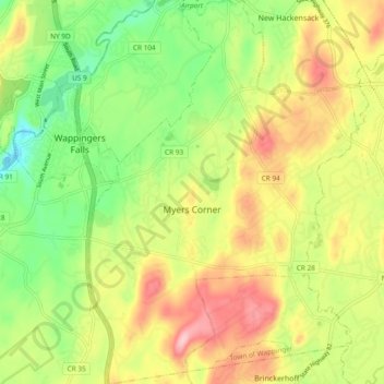
Name: Myers Corner topographic map, elevation, terrain.
Average elevation: 75 m
Minimum elevation: -2 m
Maximum elevation: 160 m
Make a donation
Other topographic maps
Click on a map to view its topography, its elevation and its terrain.
Shenandoah
United States > New York > Dutchess County > Town of East Fishkill
Average elevation: 153 m
Annandale-on-Hudson
United States > New York > Dutchess County > Town of Red Hook
Average elevation: 43 m
Timothy Heights
United States > New York > Dutchess County > Town of Pleasant Valley
Average elevation: 87 m
Make a donation
Make a donation
Drayton Grant Park at Burger Hill
United States > New York > Dutchess County > Town of Rhinebeck
Average elevation: 102 m
Stissing Mountain Multiple Use Area
United States > New York > Dutchess County > Town of Pine Plains
Average elevation: 217 m
Make a donation
Alamar Unit
United States > New York > Dutchess County > Town of East Fishkill
Average elevation: 278 m
Pecksville
United States > New York > Dutchess County > Town of East Fishkill
Average elevation: 274 m
Stormville
United States > New York > Dutchess County > Town of East Fishkill
Average elevation: 112 m
Make a donation
Make a donation
Netherwood
United States > New York > Dutchess County > Town of Pleasant Valley
Average elevation: 110 m
Make a donation
United States of America Property
United States > New York > Dutchess County > Village of Pawling
Average elevation: 251 m
Make a donation
Make a donation