
Make a donation
Italy topographic map
Click on the map to display elevation.
Make a donation
About this map
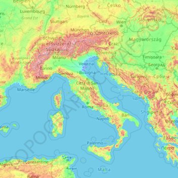
Name: Italy topographic map, elevation, terrain.
Location: Italy (35.13843 5.17430 50.13843 20.17430)
Average elevation: 335 m
Minimum elevation: -5 m
Maximum elevation: 4,188 m
Make a donation
Other topographic maps
Click on a map to view its topography, its elevation and its terrain.
Lake Como
Lake Como weather is humid subtropical (Cfa in the Köppen climate classification). In winter, the lake helps to maintain a higher temperature in the surrounding region. Average daily temperatures range from ~3.7 °C (39 °F) in January to 23.4 °C (74 °F) in July, according to historical weather data from…
Average elevation: 885 m
Sardinia
The climate of the island is variable from area to area, due to several factors including the extension in latitude and the elevation. It can be classified in two different macrobioclimates (Mediterranean pluviseasonal oceanic and Temperate oceanic), one macrobioclimatic variant, called Submediterranean, and…
Average elevation: 115 m
Lake Garda
The particularly mild climate favours the growth of some hardy Mediterranean plants, including the olive tree, parasol pine, mediterranean cypress, chinese windmill palm and Canary Island Date Palm. Some hardy citrus trees, such as hardy lemons and satsuma can also be found, which are extremely rare at this…
Average elevation: 571 m
Make a donation
Alps
The altitude and size of the range affects the climate in Europe; in the mountains precipitation levels vary greatly and climatic conditions consist of distinct zones. Wildlife such as ibex live in the higher peaks to elevations of 3,400 m (11,155 ft), and plants such as Edelweiss grow in rocky areas in lower…
Average elevation: 1,284 m
Matera
Italy > Basilicata > Matera
The Sassi consist of around twelve levels spanning the height of 380 m, connected by a network of paths, stairways, and courtyards (vicinati). The medieval city clinging on to the edge of the canyon for its defence is invisible from the western approach. The tripartite urban structure of Civita and the two…
Average elevation: 293 m
Make a donation
Mount Etna
Italy > Sicily > Maletto > Adrano
During the first 1500 years AD, many eruptions went unrecorded (or records have been lost); among the more significant are: (1) an eruption in about 1030 AD near Monte Ilice on the lower southeast flank, which produced a lava flow that travelled about 10 km, reaching the sea north of Acireale; the villages of…
Average elevation: 1,157 m
Make a donation
Dolina Seghina / Šeginov Dol
Italy > Friuli-Venezia Giulia > Trieste > Gabrovizza / Gabrovec > Stazione di Prosecco / Proseška Postaja
Average elevation: 249 m
Seiser Alm-Gruppe - Gruppo Mont de Sëuc - Gruppo dell'Alpe di Siusi
Italy > Trentino – Alto Adige/Südtirol > South Tyrol > Kastelruth - Castelrotto
Seiser Alm (Italian: Alpe di Siusi, Ladin: Mont Sëuc) is a Dolomite plateau and the largest high-elevation Alpine meadow (German: Alm) in Europe. Located in Italy's South Tyrol province in the Dolomites mountain range, it is a major tourist attraction, notably for skiing and hiking.
Average elevation: 1,466 m
Make a donation
Lake Maggiore
Italy > Piedmont > Verbano-Cusio-Ossola
Lake Maggiore weather is humid subtropical (Cfa in the Köppen climate classification). During winter, the lake helps to maintain a higher temperature in the surrounding region (since water releases heat energy more slowly than air). The temperatures are cooled down in summer by the breezes that blow on the…
Average elevation: 655 m
Make a donation
Monte Isola
The municipality covers a total area of 12.8 square kilometres (4.9 sq mi); the main island, Monte Isola, with an area of 4.5 square kilometres (1.7 sq mi) ranks as the largest lake island not only in Italy, but also in South and Central Europe, but is dwarfed by the large lake islands in Northern Europe. The…
Average elevation: 220 m
Make a donation
Make a donation
Make a donation
Karer See - Lago di Carezza
Italy > Trentino-Alto Adige/Südtirol > South Tyrol > Karersee - Carezza
The lake is located in the western Dolomites on the edge of the Latemarwald, just 20 kilometers southeast of Bolzano at 1520 m altitude in the municipality Welschnofen. The nearest settlement is Carezza. The roughly 300 m long and 140 m wide stretch of water is fed by underground springs from the Latemar…
Average elevation: 1,606 m
San Vito dei Normanni
The town is located in the northeast of the Salento plains, not far from the Itria Valley. The geomorphology of the land is flat, slightly undulating on the border with the municipalities of Carovigno and Ostuni. It is located 9 kilometres (6 miles) from the Adriatic coast, the port nearest beach Specchiolla,…
Average elevation: 107 m
Make a donation
Santo Stefano Quisquina
Santo Stefano Quisquina stands at an altitude of 730 metres (2,400 ft) above sea level and borders the following municipalities: Alessandria della Rocca, Bivona, Cammarata, Casteltermini, Castronovo di Sicilia, San Biagio Platani.
Average elevation: 642 m
Make a donation
Castel del Monte
Castel del Monte is situated on a small hill close to the monastery of Santa Maria del Monte, at an altitude of 540 metres (1,770 ft). When the castle was built, the region was famously fertile with a plentiful supply of water and lush vegetation. It lies in the comune of Andria, province of…
Average elevation: 453 m
Make a donation
Welsberg-Taisten - Monguelfo-Tesido
Italy > Trentino-Alto Adige/Südtirol > South Tyrol > Welsberg-Taisten - Monguelfo-Tesido
Average elevation: 1,569 m
Belluno
The national park includes mountain ranges of Alpi Feltrine (Vette di Feltre, Cimonega, Pizzocco, Brendol, Agnelezze), Monti del Sole, Schiara, Talvena, Prampèr, and Spiz di Mezzodì. There are high-altitude areas, karst rocks, and debris slopes, ideal habitat for high-mountain species.
Average elevation: 1,121 m
Make a donation
Fiume Brenta
Italy > Trentino-Alto Adige/Südtirol > Provincia di Trento > Caldonazzo > Brenta
Average elevation: 470 m
Make a donation
Gruppo del Catinaccio
Italy > Trentino-Alto Adige/Südtirol > Provincia di Trento
Average elevation: 1,863 m
Make a donation
Make a donation
Make a donation
Make a donation
Make a donation
Make a donation
Afers - Eores
Italy > Trentino – Alto Adige/Südtirol > South Tyrol > Brixen - Bressanone
Average elevation: 1,632 m
Make a donation
Make a donation
Make a donation
Make a donation
Albeins - Albes
Italy > Trentino – Alto Adige/Südtirol > South Tyrol > Brixen - Bressanone
Average elevation: 729 m
Eppan an der Weinstraße - Appiano sulla Strada del Vino
Italy > Trentino – Alto Adige/Südtirol > South Tyrol
Average elevation: 701 m
Make a donation
Make a donation