
Thank you for supporting this site ❤️
Make a donation
Make a donation
Termoli topographic map
Click on the map to display elevation.
Thank you for supporting this site ❤️
Make a donation
Make a donation
About this map
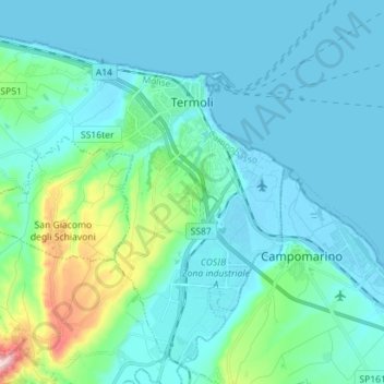
Name: Termoli topographic map, elevation, terrain.
Location: Termoli, Campobasso, Molise, 86039, Italy (41.92609 14.88990 42.02148 15.03102)
Average elevation: 43 m
Minimum elevation: -3 m
Maximum elevation: 299 m
Thank you for supporting this site ❤️
Make a donation
Make a donation
Other topographic maps
Click on a map to view its topography, its elevation and its terrain.