
Thank you for supporting this site ❤️
Make a donation
Make a donation
Dundas Parish topographic map
Click on the map to display elevation.
Thank you for supporting this site ❤️
Make a donation
Make a donation
About this map
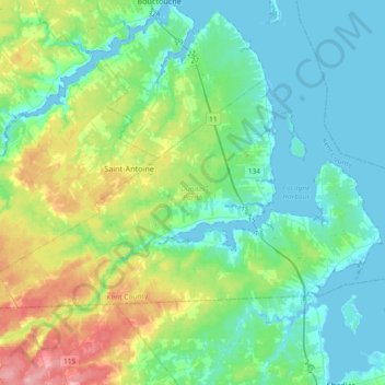
Name: Dundas Parish topographic map, elevation, terrain.
Location: Dundas Parish, Kent County, New Brunswick, Canada (46.27068 -64.87877 46.42285 -64.50963)
Average elevation: 31 m
Minimum elevation: -5 m
Maximum elevation: 129 m
Thank you for supporting this site ❤️
Make a donation
Make a donation
Other topographic maps
Click on a map to view its topography, its elevation and its terrain.
Thank you for supporting this site ❤️
Make a donation
Make a donation
Thank you for supporting this site ❤️
Make a donation
Make a donation
Thank you for supporting this site ❤️
Make a donation
Make a donation
Sainte-Anne-de-Kent
Canada > New Brunswick > Kent County > Sainte-Anne-de-Kent
Average elevation: 21 m