Geolocate

Saint-Norbert topographic map

Click on the map to display elevation.

About this map

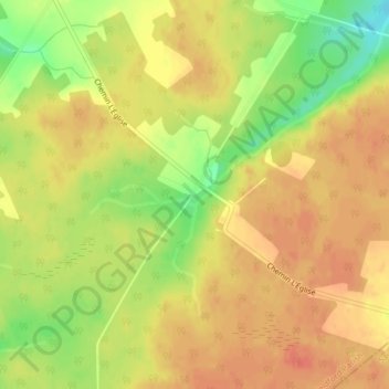
Name: Saint-Norbert topographic map, elevation, terrain.

Location: Saint-Norbert, Weldford Parish, Kent County, New Brunswick, Canada (46.45844 -64.98064 46.47844 -64.96064)

Average elevation: 62 m

Minimum elevation: 31 m

Maximum elevation: 78 m

Other topographic maps

Click on a map to view its topography, its elevation and its terrain.

Saint-Paul Parish

Canada > New Brunswick > Kent County

Average elevation: 70 m

Harcourt Parish

Canada > New Brunswick > Kent County

Average elevation: 77 m

Dundas Parish

Canada > New Brunswick > Kent County

Average elevation: 31 m

McLean Brook

Canada > New Brunswick > Kent County

Average elevation: 53 m

Richibucto

Canada > New Brunswick > Kent County > Richibucto

Average elevation: 4 m