Geolocate

Keffi topographic map

Interactive map

Click on the map to display elevation.

About this map

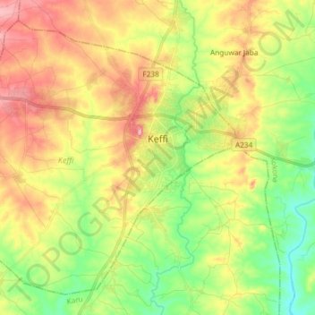
Name: Keffi topographic map, elevation, terrain.

Location: Keffi, Nasarawa State, Nigeria (8.77344 7.76650 8.90011 7.91362)

Average elevation: 304 m

Minimum elevation: 240 m

Maximum elevation: 379 m

Other topographic maps

Click on a map to view its topography, its elevation and its terrain.

Karu

Nigeria > Nasarawa State

Average elevation: 422 m

Akwanga

Nigeria > Nasarawa State > Akwanga

Average elevation: 437 m

Kokona

Nigeria > Nasarawa State

Average elevation: 334 m

Awe

Nigeria > Nasarawa State > Awe

Average elevation: 144 m

Adawa

Nigeria > Nasarawa State > Awe

Average elevation: 165 m

Ukpo

Nigeria > Nasarawa State > Awe > Ukpo

Average elevation: 173 m