
Make a donation
Biltmore Forest topographic map
Click on the map to display elevation.
Make a donation
About this map
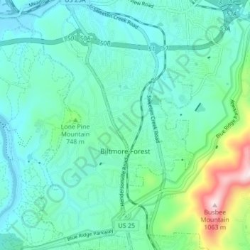
Name: Biltmore Forest topographic map, elevation, terrain.
Average elevation: 689 m
Minimum elevation: 601 m
Maximum elevation: 1,052 m
Make a donation
Other topographic maps
Click on a map to view its topography, its elevation and its terrain.
Arden
United States > North Carolina > Buncombe County > Asheville > Royal Pines
Average elevation: 693 m
Haw Creek Park
United States > North Carolina > Buncombe County > Asheville > Dogwood Grove
Average elevation: 666 m
Make a donation
Make a donation
Biltmore Village
United States > North Carolina > Buncombe County > Asheville
Average elevation: 642 m
Make a donation
Make a donation
Make a donation
Make a donation
Royal Pines
United States > North Carolina > Buncombe County > Asheville
Royal Pines is located in southern Buncombe County at 35°28′39″N 82°30′35″W / 35.47750°N 82.50972°W / 35.47750; -82.50972 (35.477386, -82.509833). It is bordered to the west by U.S. Route 25A and the city limits of Asheville, and to the northeast by Mills Gap Road. Brown Mountain, with an…
Average elevation: 700 m
Make a donation
Aston Park
United States > North Carolina > Buncombe County > Asheville > River Arts District
Average elevation: 641 m