
Thank you for supporting this site ❤️
Make a donation
Make a donation
Lansing topographic map
Click on the map to display elevation.
Thank you for supporting this site ❤️
Make a donation
Make a donation
About this map
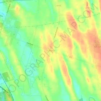
Name: Lansing topographic map, elevation, terrain.
Average elevation: 115 m
Minimum elevation: 92 m
Maximum elevation: 136 m
Thank you for supporting this site ❤️
Make a donation
Make a donation
Other topographic maps
Click on a map to view its topography, its elevation and its terrain.
City of Oswego
United States > New York > Oswego County
Oswego is located on the southeastern shore of Lake Ontario at the mouth of the Oswego River, approximately 35 miles north of Syracuse and 69 miles east of Rochester. The elevation is 298 feet above sea level. The nearest city is Fulton, located south of Oswego and north of Syracuse.
Average elevation: 87 m
Thank you for supporting this site ❤️
Make a donation
Make a donation
Thank you for supporting this site ❤️
Make a donation
Make a donation