
Thank you for supporting this site ❤️
Make a donation
Make a donation
Irving topographic map
Click on the map to display elevation.
Thank you for supporting this site ❤️
Make a donation
Make a donation
About this map
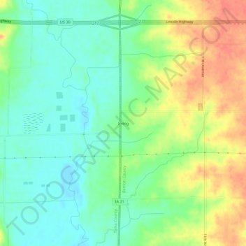
Name: Irving topographic map, elevation, terrain.
Location: Irving, Benton County, Iowa, United States (41.92774 -92.31698 41.96774 -92.27698)
Average elevation: 259 m
Minimum elevation: 236 m
Maximum elevation: 292 m
Thank you for supporting this site ❤️
Make a donation
Make a donation
Other topographic maps
Click on a map to view its topography, its elevation and its terrain.
Thank you for supporting this site ❤️
Make a donation
Make a donation
Thank you for supporting this site ❤️
Make a donation
Make a donation