
Greece topographic map
Interactive map
Click on the map to display elevation.
About this map
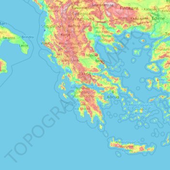
Name: Greece topographic map, elevation, terrain.
Location: Greece (34.70061 19.24779 41.74889 29.72970)
Average elevation: 170 m
Minimum elevation: -7 m
Maximum elevation: 2,691 m
Eighty percent of Greece consists of mountains or hills, making the country one of the most mountainous in Europe. Mount Olympus, the mythical abode of the Greek Gods, culminates at Mytikas peak 2,918 metres (9,573 ft), the highest in the country. Western Greece contains a number of lakes and wetlands and is dominated by the Pindus mountain range. The Pindus, a continuation of the Dinaric Alps, reaches a maximum elevation of 2,637 m (8,652 ft) at Mt. Smolikas (the second-highest in Greece) and historically has been a significant barrier to east-west travel.
Other topographic maps
Click on a map to view its topography, its elevation and its terrain.
Athens
Greece > Attica > Regional Unit of Central Athens
Athens, Municipality of Athens, Regional Unit of Central Athens, Attica, 105 57, Greece
Average elevation: 168 m
Plakias
Greece > Region of Crete > Rethymno Regional Unit
Plakias, Municipality of Agios Vasileios, Rethymno Regional Unit, Region of Crete, 740 60, Greece
Average elevation: 123 m
Municipal Unit of Vocha
Greece > Peloponnese, Western Greece and the Ionian > Corinthia Regional Unit
Municipal Unit of Vocha, Municipality of Velo and Vocha, Corinthia Regional Unit, Peloponnese Region, Peloponnese, Western Greece and the Ionian, Greece
Average elevation: 203 m
Municipality of Patras
Greece > Peloponnese, Western Greece and the Ionian > Achaea Regional Unit
Municipality of Patras, Achaea Regional Unit, Western Greece, Peloponnese, Western Greece and the Ionian, Greece
Average elevation: 291 m
Santorini
Greece > Aegean > Thira Municipal Unit
Santorini, Thira Municipal Unit, Δήμος Θήρας, Thira Regional Unit, South Aegean Region, Aegean, Greece
Average elevation: 30 m
Volos
Greece > Thessaly - Central Greece > Volos
Volos, Volos Municipality, Regional Unit of Magnesia, Region of Thessaly, Thessaly - Central Greece, 38001, Greece
Average elevation: 249 m
Panteli
Greece > Aegean > Vromolithos
Panteli, Vromolithos, Δήμος Λέρου, Kalmynos Regional Unit, South Aegean Region, Aegean, 854 00, Greece
Average elevation: 33 m
Pindus
Greece > Thessaly - Central Greece
Pindus, Δήμος Αργιθέας, Karditsa Regional Unit, Region of Thessaly, Thessaly - Central Greece, Greece
Average elevation: 1,510 m
Mitikas
Greece > Thessaly - Central Greece
Mitikas, Skiathos Municipality, Regional Unit of Sporades, Region of Thessaly, Thessaly - Central Greece, 37002, Greece
Average elevation: 261 m
Patras
Greece > Peloponnese, West Greece and Ionian Sea > Patras
Patras, Patra Municipality, Achaea Regional Unit, West Greece Region, Peloponnese, West Greece and Ionian Sea, 26221, Greece
Average elevation: 283 m
Σμόλικας
Greece > Epirus - Western Macedonia
Σμόλικας, Konitsa Municipality, Ioannina Regional Unit, Epirus Region, Epirus - Western Macedonia, 44019, Greece
Average elevation: 2,199 m
Highest Point
Greece > Peloponnese, West Greece and Ionian Sea
Highest Point, Δήμος Παξών, Corfu Regional Unit, Ionian Islands Region, Peloponnese, West Greece and Ionian Sea, 49082, Greece
Average elevation: 99 m