
Thank you for supporting this site ❤️
Make a donation
Make a donation
Sand Mountain topographic map
Click on the map to display elevation.
Thank you for supporting this site ❤️
Make a donation
Make a donation
About this map
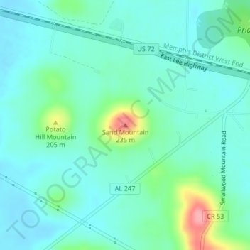
Name: Sand Mountain topographic map, elevation, terrain.
Location: Sand Mountain, Colbert County, Alabama, United States (34.71698 -87.82869 34.71708 -87.82859)
Average elevation: 151 m
Minimum elevation: 129 m
Maximum elevation: 232 m
Thank you for supporting this site ❤️
Make a donation
Make a donation
Other topographic maps
Click on a map to view its topography, its elevation and its terrain.