
Dome Glacier topographic map
Interactive map
Click on the map to display elevation.
About this map
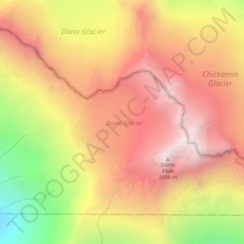
Name: Dome Glacier topographic map, elevation, terrain.
Location: Dome Glacier, Chelan County, Washington, United States (48.30031 -121.04878 48.31156 -121.02939)
Average elevation: 2,148 m
Minimum elevation: 1,316 m
Maximum elevation: 2,698 m
Other topographic maps
Click on a map to view its topography, its elevation and its terrain.
West Richland
United States > Washington > Benton County
The original people of the region were the Chemnapum Indians (closely related to the Wanapum tribe), living near the mouth of the Yakima River. Lewis and Clark passed through the area in 1805, and an expedition of the Army Corps of Topographical Engineers headed by Robert E Johnson mapped the Yakima Valley in…
Average elevation: 146 m
Tacoma
United States > Washington > Pierce County > Tacoma
Tacoma is at 47°14′29″N 122°27′34″W / 47.24139°N 122.45944°W / 47.24139; -122.45944 (47.241371, −122.459389). Its official elevation is 381 feet (116 m), varying between sea level and about 500 feet.
Average elevation: 67 m