Geolocate

Pampanga topographic map

Interactive map

Click on the map to display elevation.

About this map

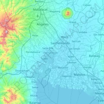
Name: Pampanga topographic map, elevation, terrain.

Location: Pampanga, Central Luzon, Philippines (14.67001 120.35851 15.27624 120.95257)

Average elevation: 86 m

Minimum elevation: -3 m

Maximum elevation: 1,408 m

Other topographic maps

Click on a map to view its topography, its elevation and its terrain.

San Luis

Philippines > Nueva Vizcaya

Average elevation: 297 m

Pasacao

Philippines > Camarines Sur

Average elevation: 31 m

Bamboo Peak

Philippines > Davao del Sur > Santa Cruz > Langan

Average elevation: 921 m

Mount Sibulan

Philippines > Davao del Sur > Santa Cruz

Average elevation: 681 m

Green Mountain View

Philippines > Davao City > Waan > Tinago

Average elevation: 122 m

Mount Candalaga

Philippines > Davao de Oro

Average elevation: 1,841 m

Mount Pandadagsaan

Philippines > Davao de Oro > New Bataan

Mount Tagubud, also known as Mount Pandadagsaan or White Peak, is the highest mountain in the province of Davao de Oro in the Philippines with an elevation of 2,650 metres (8,694 ft) above sea level. Located in New Bataan Davao de Oro, Davao Region in the island of Mindanao Philippines, Mount Tagubud is the…

Average elevation: 2,195 m

Mount Kulago

Philippines > Bukidnon > Impasugong

Average elevation: 652 m

Mount Talomo

Philippines > Davao City

Average elevation: 2,147 m

Karilongan

Philippines > Davao City

Average elevation: 908 m

Mount Loay

Philippines > Davao del Sur > Santa Cruz

Average elevation: 690 m

Bislig

Philippines > Surigao del Sur

Average elevation: 68 m

Mount Hamiguitan

Philippines > Davao Oriental > San Isidro

Average elevation: 1,219 m

Balud

Philippines > Masbate

Average elevation: 20 m

Ilasan Ibaba

Philippines

Average elevation: 214 m

Sipocot

Philippines > Camarines Sur

Average elevation: 61 m

Bacoor River

Philippines > Cavite > Bacoor

Average elevation: 8 m

San Vicente

Philippines > Pampanga > Santo Tomas

Average elevation: 3 m

Ilisan

Philippines > Zamboanga Sibugay > Ilisan

Average elevation: 29 m

San Roque

Philippines > Southern Leyte > San Roque

Average elevation: 31 m

Balete Segundo

Philippines > Cavite > Balete Segundo

Average elevation: 397 m

San Antonio

Philippines > Cavite > San Antonio

Average elevation: 1 m

Santo Cristo

Philippines > Bulacan > Santo Cristo

Average elevation: 86 m

Davao del Sur

Philippines > Davao del Sur

Average elevation: 116 m

Oyan

Philippines > Romblon > Oyan

Average elevation: 146 m

Makati

Philippines > Makati

Average elevation: 26 m

Bacolod

Philippines > Negros Occidental > Bacolod

Bacólod (English: Bacolod), is derived from bakólod (Old Spelling: bacólod), the Old Hiligaynon (Old Ilonggo) (Old Spelling: Ylongo and Ilongo) word for a "hill, mound, rise, hillock, down, any small eminence or elevation", since the resettlement was founded on a stony, hilly area, now the barangay of…

Average elevation: 49 m

Masbate

Philippines > Masbate

Average elevation: 54 m

Capiz

Philippines > Capiz

Capiz covers a total area of 2,594.64 square kilometres (1,001.80 sq mi) occupying the northeastern portion of Panay Island, and is one of the five provinces that compose the Western Visayas region. Mount Nangtud, is the highest mountain in Capiz with an elevation of 6,800 ft ( 2,073 m) located in the…

Average elevation: 56 m

Punta Engaño

Philippines > Cebu > Punta Engaño

Average elevation: 1 m

Albay

Philippines > Albay

Average elevation: 48 m

Dinagat Islands

Philippines > Dinagat Islands

Dinagat Islands is a young island-province at the northern tip of Mindanao. Many describe Dinagat Islands as a hidden gem of the Caraga Region XIII. The Islands are enriched with great bio-diversity, abundant natural wonders and rich resources. Dinagat Islands has a multitude of fascinating white sandy beaches…

Average elevation: 91 m

Bataan

Philippines > Bataan

Average elevation: 93 m

Basilan

Philippines

Basilan National Park is at the eastern portion of the remaining public forest between the city of Isabela and the municipalities of Lamitan, Tipo-Tipo and Sumisip. The park has an elevation of 971 metres (3,186 ft) above sea level, and the tallest peak, Puno Mahaji or Basilan Peak, dominates the park's…

Average elevation: 42 m