Geolocate

Basilan topographic map

Interactive map

Click on the map to display elevation.

Basilan

Basilan National Park is at the eastern portion of the remaining public forest between the city of Isabela and the municipalities of Lamitan, Tipo-Tipo and Sumisip. The park has an elevation of 971 metres (3,186 ft) above sea level, and the tallest peak, Puno Mahaji or Basilan Peak, dominates the park's landscape.

About this map

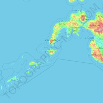
Name: Basilan topographic map, elevation, terrain.

Location: Basilan, Zamboanga Peninsula, Philippines (3.97865 119.43492 9.17865 124.63492)

Average elevation: 42 m

Minimum elevation: -2 m

Maximum elevation: 2,438 m

Other topographic maps

Click on a map to view its topography, its elevation and its terrain.

Iloilo

Philippines

The province is divided into two distinct geographic regions; the highlands of the Central Panay Mountain Range on the western border and the lowland plains which account for a larger portion of the province. Small islands east of its northernmost tip also dot the Visayan Sea - of these, Pan de Azucar and…

Average elevation: 129 m

Santa Rosa

Philippines > Laguna

Average elevation: 26 m

Dasmariñas

Philippines > Cavite

Dasmariñas is partly lowland and partly hilly. The Poblacion itself is elevated. From an elevation of 80 meters (260 ft) at the Poblacion, the land rises to 250 meters (820 ft) towards Silang. Generally, land near rivers and creeks are rugged. Dasmariñas is outside the typhoon belt and has no fault line…

Average elevation: 126 m

New Zañiga

Philippines > Mandaluyong

Average elevation: 11 m

General Trias

Philippines > Cavite

Average elevation: 85 m

Mariveles

Philippines > Bataan

Average elevation: 57 m

Amadeo

Philippines > Cavite

Average elevation: 403 m

Zamboanga City

Philippines

The overall topography of the city could be described as rolling to very steep. There are some flat lands, mostly narrow strips along the east coast. The urban center is mostly flat with a gentle slope to the interior, ranging from 0% to 3%. A portion, about 38,000 hectares, has slopes ranging from 18% to 30%.…

Average elevation: 78 m

Alabang

Philippines > Muntinlupa

Average elevation: 13 m

Biñan

Philippines > Laguna

Average elevation: 33 m

Trece Martires

Philippines > Cavite

The city of Trece Martires is characterised with ground elevation ranging from 30 metres (98 ft) to nearly 400 metres (1,300 ft). Its ground slope ranges from 0.5 to 2%.

Average elevation: 142 m

Muntinlupa

Philippines

Muntinlupa's terrain is relatively flat to sloping towards the east along the lake. Gentle rolling hills occupy the western part of the city, with elevation increasing up to 60 meters (200 ft) and above towards its southwest portion.

Average elevation: 21 m

Orani

Philippines > Bataan

Average elevation: 53 m

Tanza

Philippines > Cavite

Average elevation: 28 m

Sucat

Philippines > Muntinlupa

Average elevation: 11 m

Manila

Philippines

Almost all of Manila sits on top prehistoric alluvial deposits built by the waters of the Pasig River and on land reclaimed from Manila Bay. Manila's land has been substantially altered by human intervention; there has been considerable land reclamation along the waterfronts since the early-to-mid twentieth…

Average elevation: 12 m

Bacoor River

Philippines > Cavite > Bacoor

Average elevation: 8 m

Indang

Philippines > Cavite

The topography of Indang is characterised by gently sloping or rolling terrain. Almost 40.36% of its total land area is within the slope grade of 3-8%, while 2,135 hectares is within the slope range of 8-15% which is characterised by undulating or sloping terrain.

Average elevation: 329 m

Pampanga

Philippines

Average elevation: 86 m

Bauan

Philippines > Batangas

Average elevation: 71 m

Bolog

Philippines > Ifugao > Kiangan > Bolog

Average elevation: 1,074 m

Dasmarinas

Philippines > Cavite > Dasmarinas

Average elevation: 114 m

Balintawak

Philippines > Balintawak

Average elevation: 22 m

Poblacion

Philippines > Poblacion

Average elevation: 11 m

Marikina

Philippines > Marikina

Average elevation: 30 m

Bokod

Philippines > Benguet

Average elevation: 1,275 m

Burnay

Philippines > Ifugao > Lagawe

Average elevation: 625 m

Maguindanao

Philippines > Maguindanao

Average elevation: 218 m

Davao City

Philippines > Davao City

Average elevation: 296 m