
Saint Pierre and Miquelon topographic map
Interactive map
Click on the map to display elevation.
About this map
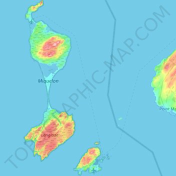
Name: Saint Pierre and Miquelon topographic map, elevation, terrain.
Location: Saint Pierre and Miquelon, 4297, France (46.74946 -56.40588 47.14426 -56.11896)
Average elevation: 11 m
Minimum elevation: -1 m
Maximum elevation: 230 m
Other topographic maps
Click on a map to view its topography, its elevation and its terrain.
Col du Galibier
France > Provence-Alpes-Côte d'Azur > Hautes-Alpes > Le Monêtier-les-Bains
Before 1976, the tunnel was the only point of passage at the top, at an altitude of 2556 m. The tunnel was closed for restoration until 2002, and a new road was constructed over the summit. The re-opened tunnel is a single lane controlled by traffic lights, which are among the highest such installations in…
Average elevation: 2,491 m
La Bachellerie-du-Nord
France > Nouvelle-Aquitaine > Haute-Vienne > Saint-Yrieix-la-Perche
Average elevation: 386 m
Plan d'eau privé
France > Pays de la Loire > Loire-Atlantique > Prinquiau > Clas
Average elevation: 54 m
Pyrenees
The Pyrenees (/ˈpɪrɪniːz/; Spanish: Pirineos [piɾiˈneos]; French: Pyrénées [piʁene] (listen); Catalan: Pirineu [piɾiˈnɛw]; Basque: Pirinioak [piɾini.o.ak]; Occitan: Pirenèus [piɾeˈnɛws]; Aragonese: Pirineus) is a mountain range straddling the border of France and Spain. It extends nearly 500…
Average elevation: 484 m
Le Planet
France > Auvergne-Rhône-Alpes > Upper Savoy > Chamonix-Mont-Blanc > Le Planet
Average elevation: 1,672 m
Les Chaussendents
France > Provence-Alpes-Côte d'Azur > Hautes-Alpes > La Chapelle-en-Valgaudémar > Les Chaussendents
Average elevation: 1,619 m
Eget Village
France > Occitania > Hautes Pyrenees > Aragnouet > Eget Village
Average elevation: 1,560 m