
Make a donation
Pisgah National Forest topographic map
Click on the map to display elevation.
Make a donation
Pisgah National Forest
The Pisgah National Forest covers 512,758 acres (801 sq mi; 2,075 km2) of mountainous terrain in the southern Appalachian Mountains, including parts of the Blue Ridge Mountains and Great Balsam Mountains. Elevations reach over 6,000 feet (1,800 m) and include some of the highest mountains in the eastern United States. Summit elevations include Black Balsam Knob at 6,214 feet (1,894 m), Mount Hardy at 6,110 feet (1,860 m), Tennant Mountain at 6,056 feet (1,846 m), and Cold Mountain at 6,030 feet (1,840 m). Mount Mitchell, in Mount Mitchell State Park, is the highest mountain east of the Mississippi River and lies just outside the boundary of Pisgah National Forest.
Make a donation
About this map
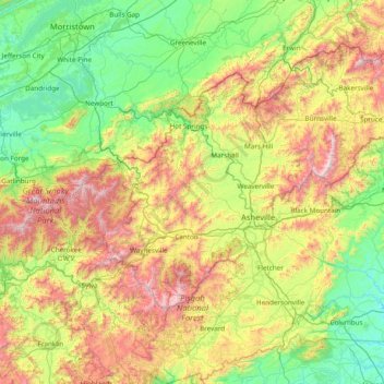
Name: Pisgah National Forest topographic map, elevation, terrain.
Average elevation: 752 m
Minimum elevation: 235 m
Maximum elevation: 2,019 m
Make a donation
Other topographic maps
Click on a map to view its topography, its elevation and its terrain.
Make a donation
Make a donation
Make a donation
Make a donation
Make a donation