
Make a donation
Division No. 10 topographic map
Click on the map to display elevation.
Make a donation
About this map
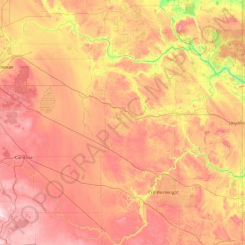
Name: Division No. 10 topographic map, elevation, terrain.
Location: Division No. 10, Alberta, Canada (52.48901 -113.18421 54.06362 -110.00537)
Average elevation: 674 m
Minimum elevation: 500 m
Maximum elevation: 903 m
Make a donation
Other topographic maps
Click on a map to view its topography, its elevation and its terrain.
Banff
Canada > Alberta > Banff > Banff
Banff is a town within Banff National Park in Alberta, Canada. It is located in Alberta's Rockies along the Trans-Canada Highway, approximately 126 km (78 mi) west of Calgary and 58 km (36 mi) east of Lake Louise. At 1,400 to 1,630 m (4,590 to 5,350 ft) above sea level, Banff is the community with the second…
Average elevation: 1,615 m
Make a donation
Make a donation
Wimborne
Canada > Alberta > Kneehill County
Wimborne is a hamlet in southern Alberta, Canada within Kneehill County. It is located approximately 58 km (36 mi) southeast of Red Deer. It has an elevation of 975 m (3,199 ft).
Average elevation: 962 m
Make a donation
Medicine Lake
Canada > Alberta > Improvement District No. 12
Wildlife is surprisingly abundant along this high altitude lake. Grizzly bear, black bear, mule deer, caribou, wolves, moose and mountain sheep are some of the larger mammals that frequent the lake area during the summer season. Bald eagles, and osprey also frequent the area and live off the fish populations.
Average elevation: 1,681 m
Make a donation
Make a donation
Make a donation
Mount Columbia
Canada > Alberta > Improvement District No. 12 > Area A (Kicking Horse/Kinbasket Lake)
Average elevation: 2,843 m
Make a donation
Make a donation
Make a donation
Fox Creek
Canada > Alberta > Town of Fox Creek
Fox Creek is a town in northwest Alberta, Canada. It is located on Highway 43, approximately 259 km (161 mi) northwest of Edmonton and 199 km (124 mi) southeast of Grande Prairie, and has an elevation of 808 m (2,651 ft).
Average elevation: 834 m
Make a donation
Make a donation
Make a donation
Conklin
Canada > Alberta > Wood Buffalo > Conklin > Conklin
Conklin is a hamlet in northern Alberta, Canada within the Regional Municipality (RM) of Wood Buffalo. It is located on Highway 881 between Fort McMurray and Lac La Biche. It lies near the west end of Christina Lake at an elevation of 575 metres (1,886 ft), and was named for John Conklin, a railroad employee.
Average elevation: 571 m
Make a donation
Paradise Valley
Canada > Alberta > County of Vermilion River > Paradise Valley
Average elevation: 636 m
Make a donation
West Bragg Creek Provincial Recreation Area
Canada > Alberta > Kananaskis Improvement District
Average elevation: 1,466 m
Make a donation
Kingman
Canada > Alberta > Camrose County > Kingman
Kingman is a hamlet in central Alberta, Canada within Camrose County. It is located approximately 27 kilometres (17 mi) north of Camrose and has an elevation of 740 metres (2,430 ft).
Average elevation: 747 m
Make a donation
Make a donation
Make a donation
Make a donation