
Thank you for supporting this site ❤️
Make a donation
Make a donation
Ife East topographic map
Click on the map to display elevation.
Thank you for supporting this site ❤️
Make a donation
Make a donation
About this map
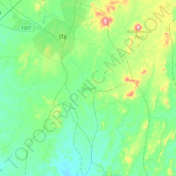
Name: Ife East topographic map, elevation, terrain.
Location: Ife East, Osun State, Nigeria (7.26828 4.54586 7.53932 4.66861)
Average elevation: 271 m
Minimum elevation: 166 m
Maximum elevation: 651 m
Thank you for supporting this site ❤️
Make a donation
Make a donation
Other topographic maps
Click on a map to view its topography, its elevation and its terrain.