
Thank you for supporting this site ❤️
Make a donation
Make a donation
Ifedayo topographic map
Click on the map to display elevation.
Thank you for supporting this site ❤️
Make a donation
Make a donation
About this map
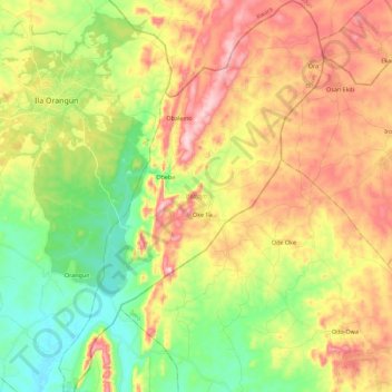
Name: Ifedayo topographic map, elevation, terrain.
Location: Ifedayo, Osun State, Nigeria (7.85025 4.90629 8.07187 5.05763)
Average elevation: 494 m
Minimum elevation: 354 m
Maximum elevation: 668 m
Thank you for supporting this site ❤️
Make a donation
Make a donation
Other topographic maps
Click on a map to view its topography, its elevation and its terrain.