
Make a donation
Adamawa topographic map
Click on the map to display elevation.
Make a donation
Adamawa
Powerful geothermal forces have shaped the Adamawa. The province begins to the south as part of the South Cameroon Plateau. The land rises gently but unevenly until about 6 degrees latitude. Here begins the Adamawa Plateau, a band of terrain that ranges from 1,000 to 2,000 m in altitude (averaging about 1,100 m) and stretches from Nigeria to the CAR. Altitude dips to as low of 500 m in the Djérem and Mbéré valleys and at the border north of Ngaoundéré. The plateau continues to about 8 degrees north before descending to the Benué Depression in abrupt cliffs and active volcanoes (though this transitional zone is mostly in the North Province).
Make a donation
About this map
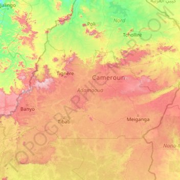
Name: Adamawa topographic map, elevation, terrain.
Location: Adamawa, Cameroon (5.97477 11.18261 8.19136 15.23362)
Average elevation: 765 m
Minimum elevation: 155 m
Maximum elevation: 2,406 m
Make a donation
Other topographic maps
Click on a map to view its topography, its elevation and its terrain.
Make a donation