
Make a donation
Dr. Phillips topographic map
Click on the map to display elevation.
Make a donation
About this map
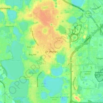
Name: Dr. Phillips topographic map, elevation, terrain.
Location: Dr. Phillips, Orange County, Florida, 32819, United States (28.42086 -81.53148 28.50086 -81.45148)
Average elevation: 36 m
Minimum elevation: 21 m
Maximum elevation: 56 m
Make a donation
Other topographic maps
Click on a map to view its topography, its elevation and its terrain.
Lake Avalon
United States > Florida > Orange County > Winter Garden > Lake Avalon Rural Settlement
Average elevation: 40 m
Make a donation
Make a donation
Make a donation
Union Park
United States > Florida > Orange County > Union Park
According to the United States Census Bureau, the CDP has a total area of 7.8 km2 (3.0 mi2), of which 7.7 km2 (3.0 mi2) is land and 0.1 km2 (0.04 mi2) (0.99%) is water. The elevation is 82 feet (25 m) above sea level.
Average elevation: 23 m
Make a donation
Make a donation
Fairview Shores CDP
United States > Florida > Orange County > Fairview Shores CDP
Average elevation: 31 m
Make a donation
Make a donation
Make a donation
Make a donation
Make a donation