
Thank you for supporting this site ❤️
Make a donation
Make a donation
Bearwallow Mountain topographic map
Click on the map to display elevation.
Thank you for supporting this site ❤️
Make a donation
Make a donation
About this map
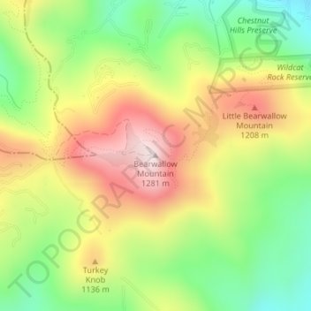
Name: Bearwallow Mountain topographic map, elevation, terrain.
Average elevation: 1,040 m
Minimum elevation: 818 m
Maximum elevation: 1,289 m
Thank you for supporting this site ❤️
Make a donation
Make a donation
Other topographic maps
Click on a map to view its topography, its elevation and its terrain.
Mills River
United States > North Carolina > Henderson County > Mills River > Oak Hill Court
Average elevation: 633 m
Echo Lake
United States > North Carolina > Henderson County > Laurel Park > Country Ridge
Average elevation: 760 m
Thank you for supporting this site ❤️
Make a donation
Make a donation
Barker Heights
United States > North Carolina > Henderson County > Barker Heights
Average elevation: 643 m
East Flat Rock
United States > North Carolina > Henderson County > Ridgeview Estates
Average elevation: 655 m
Thank you for supporting this site ❤️
Make a donation
Make a donation
Mills River
United States > North Carolina > Henderson County > Mills River > Oak Hill Court
Average elevation: 644 m