
Make a donation
Kakamega County topographic map
Click on the map to display elevation.
Make a donation
Kakamega County
Kakamega County has an altitude ranging from 1,240 metres to 2,000 metres above sea level. The southern part of the county is hilly and made of granites which raises it 1950m above sea level. The Nandi Escarpment is a key feature on the eastern border of the county with steep cliffs rising from 1700m to 2000m. The county is also endowed with a number of hills like Misango, Imanga, Eregi, Butieri, Sikhokhochole, Mawe Tatu, Lirhanda, Kiming’ini hills among others.
Make a donation
About this map
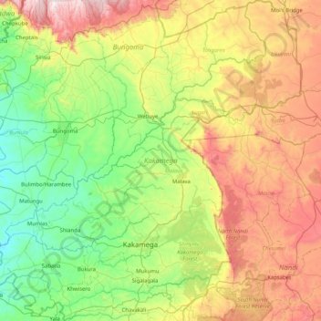
Name: Kakamega County topographic map, elevation, terrain.
Location: Kakamega County, Western, Kenya (0.08911 34.34632 0.90044 35.15589)
Average elevation: 1,660 m
Minimum elevation: 1,229 m
Maximum elevation: 2,508 m
Make a donation
Other topographic maps
Click on a map to view its topography, its elevation and its terrain.