
Make a donation
Erg Chech topographic map
Click on the map to display elevation.
Make a donation
Erg Chech
It is an almost uninhabited part of the greater Sahara Desert, an inhospitable desert region with long, extremely hot summers and short, very warm winters. The Erg Chech is a vast sandy expanse including compound and complex linear and star dunes. The mean elevation of the Erg Chech is just above 300 m, slightly lower than the neighboring Erg Iguidi stretching to the north. The barren plain of the Tanezrouft is located to the southeast.
Make a donation
About this map
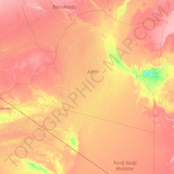
Name: Erg Chech topographic map, elevation, terrain.
Location: Erg Chech, Algeria (22.27448 -8.12346 29.36728 -0.26509)
Average elevation: 335 m
Minimum elevation: 121 m
Maximum elevation: 869 m
Make a donation
Other topographic maps
Click on a map to view its topography, its elevation and its terrain.
Algiers
Algeria > Algiers > Sidi M'Hamed District
Algiers was a walled city from the time of the deys until the close of the 19th century. The French, after their occupation of the city (1830), built a rampart, parapet and ditch, with two terminal forts, Bab Azoun باب عزون to the south and Bab-el-Oued اد to the north. The forts and part of the…
Average elevation: 45 m
Make a donation
Chlef
Algeria > Chlef > Chlef District
Chlef lies in a valley at an elevation of 114 metres (374 ft) between two ranges of hills to the north and west. The city is surrounded by farmland; there are scattered trees both in the valley and on the hills.
Average elevation: 179 m
cité des 70 logement
Algeria > Algiers > Rouiba District > Herraoua > Ouled Maamar
Average elevation: 27 m
Make a donation
Make a donation
Biskra
Algeria > Biskra > Biskra District
Biskra is located in the north-east of Algeria, in the district of Biskra. The city lies about 248 miles (399 km) from Algiers, 71 miles (114 km) southwest of Batna and 137 miles (220 km) north of Touggourt. She is nicknamed "The Queen of the Zibans", "The door of the desert" or "The Saharan Nice" because of…
Average elevation: 128 m
Make a donation
Hoggar Mountains
Algeria > Tamanrasset > de Tamanrasset District > Tamanghasset
This mountainous region is located about 1,500 km (930 mi) south of the capital, Algiers. The area is largely rocky desert with an average elevation of more than 900 m (3,000 ft) above sea level. The highest peak, Mount Tahat, is at 2,908 m (9,541 ft). The mountains are primarily composed of metamorphic rock…
Average elevation: 2,451 m
Make a donation
Make a donation
Algiers
Algeria > Algiers > Sidi M'Hamed District
Algiers was a walled city from the time of the deys until the close of the 19th century. The French, after their occupation of the city (1830), built a rampart, parapet and ditch, with two terminal forts, Bab Azoun باب عزون to the south and Bab-el-Oued اد to the north. The forts and part of the…
Average elevation: 45 m
Constantine
Algeria > Constantine > Constantine District
Constantine is situated on a plateau at an elevation 640 metres (2,100 ft) above sea level. The city is framed by a deep ravine and has a dramatic appearance. The city is very picturesque with a number of bridges over Rhumel River and a viaduct crossing the ravine. The ravine is crossed by seven bridges,…
Average elevation: 656 m
Make a donation
Hoggar Mountains
Algeria > Tamanrasset > de Tamanrasset District > Tamanghasset
This mountainous region is located about 1,500 km (930 mi) south of the capital, Algiers. The area is largely rocky desert with an average elevation of more than 900 m (3,000 ft) above sea level. The highest peak, Mount Tahat, is at 2,908 m (9,541 ft). The mountains are primarily composed of metamorphic rock…
Average elevation: 2,451 m
Make a donation
Make a donation
Make a donation
Make a donation
Bejaia
Algeria > Bejaia > Bejaia District
Béjaïa owes its existence to its port, which also makes it prosperous. It is located in a sickle-shaped bay protected from the swell of offshore winds (northwest facing) by the advance of Cape Carbon (to the west of the city). The city is backed by Mount Gouraya located in a northwest position. This port…
Average elevation: 60 m
Make a donation
Biskra
Algeria > Biskra > Biskra District
Biskra is located in the north-east of Algeria, in the district of Biskra. The city lies about 248 miles (399 km) from Algiers, 71 miles (114 km) southwest of Batna and 137 miles (220 km) north of Touggourt. She is nicknamed "The Queen of the Zibans", "The door of the desert" or "The Saharan Nice" because of…
Average elevation: 128 m
Tahat
Algeria > Tamanrasset > de Tamanrasset District > Tamanghasset
Mount Tahat (Arabic: جبل تاهات) is the highest mountain in Algeria. It sits at an elevation of 2,908 metres (9,541 ft). Other sources indicate an elevation of 3,003 metres (9,852 ft). Tahat is also the highest peak in the Hoggar Mountains. Its nearest city is Tamanrasset which is located 56 kilometres…
Average elevation: 2,466 m
Make a donation
Constantine
Algeria > Constantine > Constantine District
Constantine is situated on a plateau at an elevation 640 metres (2,100 ft) above sea level. The city is framed by a deep ravine and has a dramatic appearance. The city is very picturesque with a number of bridges over Rhumel River and a viaduct crossing the ravine. The ravine is crossed by seven bridges,…
Average elevation: 656 m
Algiers
Algeria > Algiers > Sidi M'Hamed District
Algiers was a walled city from the time of the deys until the close of the 19th century. The French, after their occupation of the city (1830), built a rampart, parapet and ditch, with two terminal forts, Bab Azoun باب عزون to the south and Bab-el-Oued اد to the north. The forts and part of the…
Average elevation: 45 m
Make a donation
Biskra
Algeria > Biskra > Biskra District
Biskra is located in the north-east of Algeria, in the district of Biskra. The city lies about 248 miles (399 km) from Algiers, 71 miles (114 km) southwest of Batna and 137 miles (220 km) north of Touggourt. She is nicknamed "The Queen of the Zibans", "The door of the desert" or "The Saharan Nice" because of…
Average elevation: 128 m
Make a donation
Make a donation
Tahat
Algeria > Tamanrasset > de Tamanrasset District > Tamanghasset
Mount Tahat (Arabic: جبل تاهات) is the highest mountain in Algeria. It sits at an elevation of 2,908 metres (9,541 ft). Other sources indicate an elevation of 3,003 metres (9,852 ft). Tahat is also the highest peak in the Hoggar Mountains. Its nearest city is Tamanrasset which is located 56 kilometres…
Average elevation: 2,466 m
Make a donation
Timimoun
Algeria > Timimoun Province > Timimoun District
The town of Timimoun lies at an elevation of around 288 metres (945 ft) in the Gourara region of southern Timimoun Province. It is located on the south-eastern side of an oasis which supports the town's population. A sebkha (salt lake) lies further to the northwest, while the plateau of Tademaït rises to the…
Average elevation: 274 m
Djanet
Algeria > Djanet > Djanet District
Due to the somewhat cooler air, higher humidity and somewhat higher rainfall in these areas, the nearby mountains support a greater amount and variety of wildlife than lower-lying areas in the Sahara, and forms part of the West Saharan montane xeric woodlands ecosystem. Djanet itself lies at an altitude of…
Average elevation: 937 m
Make a donation
Ihrir
Algeria > Djanet > Djanet District
Iherir is located at an elevation of 1,070 metres (3,510 ft) above sea level. Its valley is an oasis containing gueltas and numerous date palms. The town is notable for the dramatic rocky mountain ranges that rise as much as 300 metres (980 ft) on all sides. Prehistoric art dated to 9000 BC is found in the…
Average elevation: 1,218 m
Algiers
Algeria > Algiers > Sidi M'Hamed District
Algiers was a walled city from the time of the deys until the close of the 19th century. The French, after their occupation of the city (1830), built a rampart, parapet and ditch, with two terminal forts, Bab Azoun باب عزون to the south and Bab-el-Oued اد to the north. The forts and part of the…
Average elevation: 45 m
Make a donation
Tizi Ouzou
Algeria > Tizi Ouzou > Tizi Ouzou District
This city is located in the heart of Kabylie. It is 102.36 square kilometres (39.52 sq mi) in area. Tizi Ouzou is located in the valley of Assif N Sébaou. It is surrounded by mountains. The city is at an altitude of 200 metres (660 ft). It is bounded on the north by Mount Belloua which rises to 850 metres…
Average elevation: 266 m
Make a donation
Djelfa
Algeria > Djelfa > Djelfa District
Djelfa is located at an elevation of 3,734 feet (1,138 m) in the Ouled Naïl Range of north-central Algeria, between the towns of Bousaada and Laghouat. It is situated in a transitional zone between the dry, steppe-like Hautes Plaines (high plateaus) of the north, characterized by chotts (intermittent salt…
Average elevation: 1,194 m
Make a donation
Algiers
Algeria > Algiers > Sidi M'Hamed District
Algiers was a walled city from the time of the deys until the close of the 19th century. The French, after their occupation of the city (1830), built a rampart, parapet and ditch, with two terminal forts, Bab Azoun باب عزون to the south and Bab-el-Oued اد to the north. The forts and part of the…
Average elevation: 45 m
Make a donation
Bechar
Algeria > Bechar > Da'ira Bechar
Béchar lies at an elevation of 747 metres (2,451 ft) on the banks of Oued Béchar, which runs through the city from northeast to southwest. The rocky highlands of the Djebel Béchar overlook the city from the southeast, reaching 1,206 metres (3,957 ft) to the east of the city. Further to the northeast the…
Average elevation: 810 m
Make a donation
Make a donation
Make a donation