
Thank you for supporting this site ❤️
Make a donation
Make a donation
Aiyedire topographic map
Click on the map to display elevation.
Thank you for supporting this site ❤️
Make a donation
Make a donation
About this map
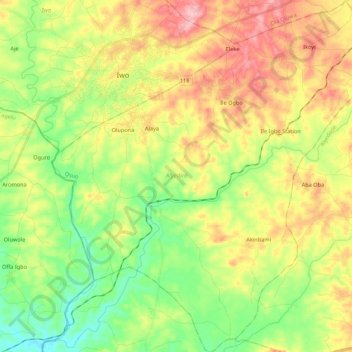
Name: Aiyedire topographic map, elevation, terrain.
Location: Aiyedire, Osun State, Nigeria (7.46460 4.13949 7.67895 4.35335)
Average elevation: 230 m
Minimum elevation: 161 m
Maximum elevation: 322 m
Thank you for supporting this site ❤️
Make a donation
Make a donation
Other topographic maps
Click on a map to view its topography, its elevation and its terrain.