
Thank you for supporting this site ❤️
Make a donation
Make a donation
Sanyo-Onoda topographic map
Click on the map to display elevation.
Thank you for supporting this site ❤️
Make a donation
Make a donation
About this map
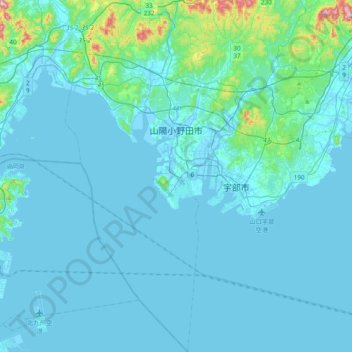
Name: Sanyo-Onoda topographic map, elevation, terrain.
Location: Sanyo-Onoda, Yamaguchi Prefecture, Japan (33.80292 131.06125 34.11961 131.22688)
Average elevation: 28 m
Minimum elevation: -5 m
Maximum elevation: 370 m
Thank you for supporting this site ❤️
Make a donation
Make a donation
Other topographic maps
Click on a map to view its topography, its elevation and its terrain.
Mount Fuji
Japan > Sunto County > Oyama
Mount Fuji (富士山, Fujisan, Japanese: [ɸɯꜜ(d)ʑisaɴ] (listen)), located on the island of Honshū, is the highest mountain in Japan, with a summit elevation of 3,776.24 m (12,389 ft 3 in). It is the second-highest volcano located on an island in Asia (after Mount Kerinci on the island of Sumatra), and…
Average elevation: 3,261 m