
New Caledonia topographic map
Interactive map
Click on the map to display elevation.
New Caledonia
The Diahot River is the longest river of New Caledonia, flowing for some 100 kilometres (62 mi). It has a catchment area of 620 km2 (240 sq mi) and opens north-westward into the Baie d'Harcourt, flowing towards the northern point of the island along the western escarpment of the Mount Panié. Most of the island is covered by wet evergreen forests, while savannahs dominate the lower elevations. The New Caledonian lagoon, with a total area of 24,000 square kilometres (9,300 sq mi) is one of the largest lagoons in the world. It is surrounded by the New Caledonia Barrier Reef.
About this map
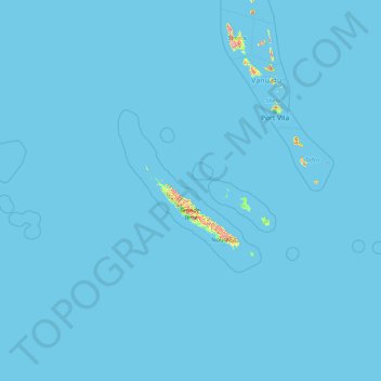
Name: New Caledonia topographic map, elevation, terrain.
Location: New Caledonia, France (-22.88171 158.23599 -18.02592 172.08988)
Average elevation: 4 m
Minimum elevation: 0 m
Maximum elevation: 1,486 m
Other topographic maps
Click on a map to view its topography, its elevation and its terrain.
Col du Galibier
France > Provence-Alpes-Côte d'Azur > Hautes-Alpes > Le Monêtier-les-Bains
Before 1976, the tunnel was the only point of passage at the top, at an altitude of 2556 m. The tunnel was closed for restoration until 2002, and a new road was constructed over the summit. The re-opened tunnel is a single lane controlled by traffic lights, which are among the highest such installations in…
Average elevation: 2,491 m
La Bachellerie-du-Nord
France > Nouvelle-Aquitaine > Haute-Vienne > Saint-Yrieix-la-Perche
Average elevation: 386 m
Plan d'eau privé
France > Pays de la Loire > Loire-Atlantique > Prinquiau > Clas
Average elevation: 54 m
Pyrenees
The Pyrenees (/ˈpɪrɪniːz/; Spanish: Pirineos [piɾiˈneos]; French: Pyrénées [piʁene] (listen); Catalan: Pirineu [piɾiˈnɛw]; Basque: Pirinioak [piɾini.o.ak]; Occitan: Pirenèus [piɾeˈnɛws]; Aragonese: Pirineus) is a mountain range straddling the border of France and Spain. It extends nearly 500…
Average elevation: 484 m
Le Planet
France > Auvergne-Rhône-Alpes > Upper Savoy > Chamonix-Mont-Blanc > Le Planet
Average elevation: 1,672 m
Les Chaussendents
France > Provence-Alpes-Côte d'Azur > Hautes-Alpes > La Chapelle-en-Valgaudémar > Les Chaussendents
Average elevation: 1,619 m
Eget Village
France > Occitania > Hautes Pyrenees > Aragnouet > Eget Village
Average elevation: 1,560 m