
Thank you for supporting this site ❤️
Make a donation
Make a donation
Le Vésinet topographic map
Click on the map to display elevation.
Thank you for supporting this site ❤️
Make a donation
Make a donation
Le Vésinet
The terrain is an alluvial plain ranging in altitude from 28 meters near Le Pecq to 45 meters at the end of the Route de Montesson, with a gentle slope from northeast to southwest.
Thank you for supporting this site ❤️
Make a donation
Make a donation
About this map
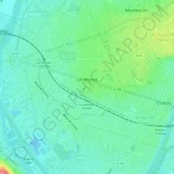
Name: Le Vésinet topographic map, elevation, terrain.
Average elevation: 37 m
Minimum elevation: 17 m
Maximum elevation: 92 m
Thank you for supporting this site ❤️
Make a donation
Make a donation
Other topographic maps
Click on a map to view its topography, its elevation and its terrain.
Le Champtier des Fourneaux
France > Ile-de-France > Yvelines > Dampierre-en-Yvelines
Average elevation: 143 m
Thank you for supporting this site ❤️
Make a donation
Make a donation
Val des Quatre Pignons
France > Ile-de-France > Yvelines > Beynes > Val des Quatre Pignons
Average elevation: 92 m
Thank you for supporting this site ❤️
Make a donation
Make a donation