
City of Binghamton topographic map
Interactive map
Click on the map to display elevation.
About this map
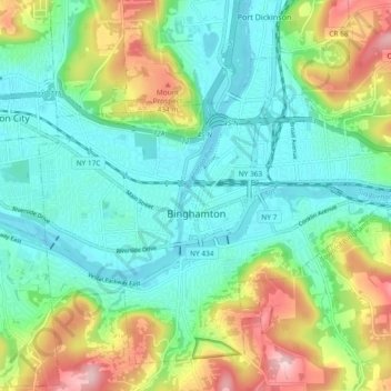
Name: City of Binghamton topographic map, elevation, terrain.
Average elevation: 321 m
Minimum elevation: 248 m
Maximum elevation: 488 m
Binghamton, like all of the Southern Tier of New York, lies on the Allegheny Plateau; hence its hilly terrain. As such, elevations can vary in the city--Downtown, for example, is at an elevation of around 860 feet, while residential homes in the hills can go up to over 1,800 feet, such as on Ingram Hill. The highest peak in Binghamton is Table Rock Ridge, which is at 1,854 feet.
Other topographic maps
Click on a map to view its topography, its elevation and its terrain.
Town of Vestal
United States > New York > Broome County
Town of Vestal, Broome County, New York, United States
Average elevation: 372 m
Ouaquaga
United States > New York > Broome County
Ouaquaga, Town of Colesville, Broome County, New York, 13826, United States
Average elevation: 352 m
Nineveh
United States > New York > Broome County
Nineveh, Town of Colesville, Broome County, New York, United States
Average elevation: 338 m
Port Crane
United States > New York > Broome County
Port Crane, Town of Fenton, Broome County, New York, 13745, United States
Average elevation: 346 m
Village of Port Dickinson
United States > New York > Broome County
Village of Port Dickinson, Town of Dickinson, Broome County, New York, United States
Average elevation: 288 m
Town of Lisle
United States > New York > Broome County
Town of Lisle, Broome County, New York, United States
Average elevation: 380 m
Glen Aubrey
United States > New York > Broome County > Town of Nanticoke
Glen Aubrey, Town of Nanticoke, Broome County, New York, United States
Average elevation: 372 m
Conklin Center
United States > New York > Broome County > Town of Conklin
Conklin Center, Town of Conklin, Broome County, New York, 13748, United States
Average elevation: 311 m
West Windsor
United States > New York > Broome County
West Windsor, Town of Windsor, Broome County, New York, 13795, United States
Average elevation: 457 m
Kopernik Observatory & Science Center
United States > New York > Broome County > Town of Vestal > Tracy Creek
Kopernik Observatory & Science Center, 698, Underwood Road, Tracy Creek, Town of Vestal, Broome County, New York, 13850, United States
Average elevation: 452 m
Conklin Forks
United States > New York > Broome County > Town of Conklin
Conklin Forks, Town of Conklin, Broome County, New York, United States
Average elevation: 405 m
Town of Fenton
United States > New York > Broome County
Town of Fenton, Broome County, New York, United States, Chenango Valley State Park
Average elevation: 315 m
Town of Fenton
United States > New York > Broome County
Town of Fenton, Broome County, New York, United States
Average elevation: 376 m
Doraville
United States > New York > Broome County
Doraville, Town of Colesville, Broome County, New York, 13813, United States
Average elevation: 370 m
Town of Colesville
United States > New York > Broome County
Town of Colesville, Broome County, New York, United States
Average elevation: 423 m
Town of Sanford
United States > New York > Broome County
Town of Sanford, Broome County, New York, 13754, United States
Average elevation: 462 m
Harpursville
United States > New York > Broome County
Harpursville, Town of Colesville, Broome County, New York, 13787, United States
Average elevation: 351 m
Ross Corners
United States > New York > Broome County > Town of Vestal
Ross Corners, Town of Vestal, Broome County, New York, United States
Average elevation: 304 m
Town of Windsor
United States > New York > Broome County
Town of Windsor, Broome County, New York, United States
Average elevation: 434 m
Town of Triangle
United States > New York > Broome County
Town of Triangle, Broome County, New York, 13862, United States
Average elevation: 409 m
Center Lisle
United States > New York > Broome County > Town of Lisle
Center Lisle, Town of Lisle, Broome County, New York, 13797, United States
Average elevation: 384 m
Town of Maine
United States > New York > Broome County
Town of Maine, Broome County, New York, 13802, United States
Average elevation: 390 m
Village of Windsor
United States > New York > Broome County > Town of Windsor
Village of Windsor, Town of Windsor, Colesville, Broome County, New York, United States
Average elevation: 334 m
State University of New York at Binghamton
United States > New York > Broome County > Town of Vestal
State University of New York at Binghamton, Town of Vestal, Town of Binghamton, Broome County, New York, 13902, United States
Average elevation: 320 m
Endwell
United States > New York > Broome County
Endwell, Town of Union, Broome County, New York, United States
Average elevation: 298 m
Chenango Bridge
United States > New York > Broome County
Chenango Bridge, Town of Chenango, Broome County, New York, 13745, United States
Average elevation: 310 m
Castle Creek
United States > New York > Broome County
Castle Creek, Town of Chenango, Broome County, New York, 13744, United States
Average elevation: 381 m
Village of Deposit
United States > New York > Broome County
Village of Deposit, Town of Sanford, Broome County, New York, United States
Average elevation: 356 m
Binghamton
United States > New York > Broome County
Binghamton, City of Binghamton, Broome County, New York, 13903, United States
Average elevation: 397 m
Susquehanna River
United States > New York > Broome County > Town of Kirkwood
Susquehanna River, Hallstead, Town of Kirkwood, Dickinson, Broome County, New York, United States
Average elevation: 411 m
Town of Kirkwood
United States > New York > Broome County
Town of Kirkwood, Broome County, New York, United States
Average elevation: 401 m
Johnson City
United States > New York > Broome County > Johnson City
Johnson City, Union Town, Broome County, New York, 13790-3202, United States
Average elevation: 322 m
Town of Binghamton
United States > New York > Broome County
Town of Binghamton, Broome County, New York, 13903, United States
Average elevation: 418 m
Town of Conklin
United States > New York > Broome County
Town of Conklin, Broome County, New York, United States
Average elevation: 381 m
Conklin
United States > New York > Broome County > Conklin
Conklin, Conklin Town, Broome County, New York, 13748, United States
Average elevation: 322 m
Cascade Valley
United States > New York > Broome County > Town of Windsor > Cascade Valley
Cascade Valley, Town of Windsor, Broome County, New York, 18827, United States
Average elevation: 415 m
Vestal
United States > New York > Broome County > Vestal
Vestal, Vestal Town, Broome County, New York, 13850-1542, United States
Average elevation: 321 m
Village of Whitney Point
United States > New York > Broome County
Village of Whitney Point, Town of Triangle, Broome County, New York, United States
Average elevation: 327 m
Pleasant Hill
United States > New York > Broome County > Pleasant Hill
Pleasant Hill, Fenton Town, Broome County, New York, 13833, United States
Average elevation: 416 m
Village of Endicott
United States > New York > Broome County
Village of Endicott, Town of Union, Broome County, New York, 13760, United States
Average elevation: 292 m
Maine
United States > New York > Broome County > Maine
Maine, Maine Town, Broome County, New York, 13802, United States
Average elevation: 351 m
Chenango Forks
United States > New York > Broome County
Chenango Forks, Town of Chenango, Broome County, New York, 13746, United States
Average elevation: 334 m
McClure
United States > New York > Broome County > Town of Sanford
McClure, Town of Sanford, Broome County, New York, United States
Average elevation: 433 m