
Thank you for supporting this site ❤️
Make a donation
Make a donation
Oliverea topographic map
Click on the map to display elevation.
Thank you for supporting this site ❤️
Make a donation
Make a donation
About this map
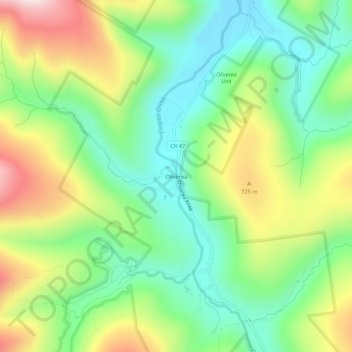
Name: Oliverea topographic map, elevation, terrain.
Average elevation: 591 m
Minimum elevation: 396 m
Maximum elevation: 917 m
Thank you for supporting this site ❤️
Make a donation
Make a donation
Other topographic maps
Click on a map to view its topography, its elevation and its terrain.
Slide Mountain Wilderness
United States > New York > Ulster County > Town of Shandaken > Town of Denning
Within its boundaries lie 10 of the 35 Catskill High Peaks, including the highest Catskill peak, Slide, 4,180 feet (1277 m) of elevation; and lowest, Rocky.
Average elevation: 584 m
Big Indian Park
United States > New York > Ulster County > Town of Shandaken > Big Indian
Average elevation: 493 m