
Thank you for supporting this site ❤️
Make a donation
Make a donation
Ilesha East topographic map
Click on the map to display elevation.
Thank you for supporting this site ❤️
Make a donation
Make a donation
About this map
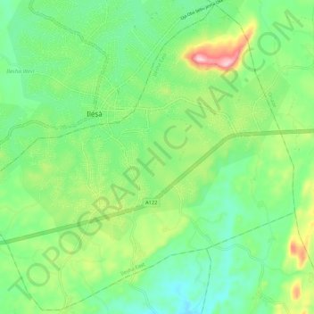
Name: Ilesha East topographic map, elevation, terrain.
Location: Ilesha East, Osun State, Nigeria (7.55876 4.70313 7.66130 4.80927)
Average elevation: 386 m
Minimum elevation: 292 m
Maximum elevation: 593 m
Thank you for supporting this site ❤️
Make a donation
Make a donation
Other topographic maps
Click on a map to view its topography, its elevation and its terrain.