
Thank you for supporting this site ❤️
Make a donation
Make a donation
Glengary topographic map
Click on the map to display elevation.
Thank you for supporting this site ❤️
Make a donation
Make a donation
About this map
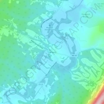
Name: Glengary topographic map, elevation, terrain.
Average elevation: 188 m
Minimum elevation: 147 m
Maximum elevation: 438 m
Thank you for supporting this site ❤️
Make a donation
Make a donation
Other topographic maps
Click on a map to view its topography, its elevation and its terrain.
West Martinsburg Historic District
United States > West Virginia > Berkeley County > Martinsburg > Rosemont
Average elevation: 149 m
Berkeley Place
United States > West Virginia > Berkeley County > Martinsburg > Berkeley Place
Average elevation: 142 m