
Make a donation
Raon-l'Étape topographic map
Click on the map to display elevation.
Make a donation
Raon-l'Étape
Raon-l'Étape is positioned at the mouth of the Plaine [fr] at the point where it converges into the Meurthe, itself a tributary of the Moselle. Because it is on departmental frontier with the adjacent Meurthe-et-Moselle département, Raon-l'Étape is sometimes known as the "Gateway to the Vosges" (porte des Vosges). The town is positioned at a point where relatively flat lands transform into a much more mountainous topography: the mountains have for centuries restricted the options for travellers between francophone France and Alsace (formerly the western reaches of the Empire on the other side of the Vosges). The position of Raon has therefore been critical to influencing the movements of merchandise in peace time and of armies in war time for many centuries.
Make a donation
About this map
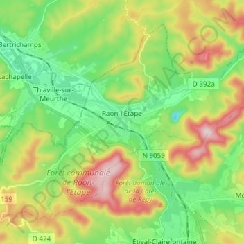
Name: Raon-l'Étape topographic map, elevation, terrain.
Average elevation: 362 m
Minimum elevation: 219 m
Maximum elevation: 604 m
Make a donation
Other topographic maps
Click on a map to view its topography, its elevation and its terrain.
Make a donation
Make a donation
Make a donation