
Thank you for supporting this site ❤️
Make a donation
Make a donation
Grand-Santi topographic map
Click on the map to display elevation.
Thank you for supporting this site ❤️
Make a donation
Make a donation
About this map
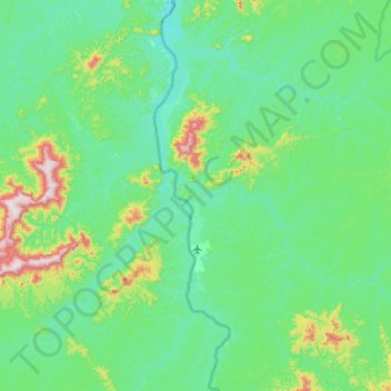
Name: Grand-Santi topographic map, elevation, terrain.
Average elevation: 115 m
Minimum elevation: 9 m
Maximum elevation: 675 m
Thank you for supporting this site ❤️
Make a donation
Make a donation
Other topographic maps
Click on a map to view its topography, its elevation and its terrain.
Thank you for supporting this site ❤️
Make a donation
Make a donation
Thank you for supporting this site ❤️
Make a donation
Make a donation
Saint-Laurent-du-Maroni
France > French Guiana > Saint-Laurent-du-Maroni > Saint-Laurent-du-Maroni
Average elevation: 9 m