
Thank you for supporting this site ❤️
Make a donation
Make a donation
Ragland topographic map
Click on the map to display elevation.
Thank you for supporting this site ❤️
Make a donation
Make a donation
About this map
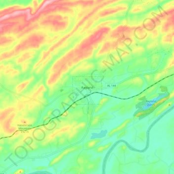
Name: Ragland topographic map, elevation, terrain.
Location: Ragland, St. Clair County, Alabama, United States (33.70720 -86.18558 33.78008 -86.07802)
Average elevation: 188 m
Minimum elevation: 120 m
Maximum elevation: 286 m
Thank you for supporting this site ❤️
Make a donation
Make a donation
Other topographic maps
Click on a map to view its topography, its elevation and its terrain.
Thank you for supporting this site ❤️
Make a donation
Make a donation
Thank you for supporting this site ❤️
Make a donation
Make a donation
Thank you for supporting this site ❤️
Make a donation
Make a donation