
Thank you for supporting this site ❤️
Make a donation
Make a donation
Springville topographic map
Click on the map to display elevation.
Thank you for supporting this site ❤️
Make a donation
Make a donation
About this map
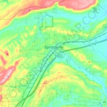
Name: Springville topographic map, elevation, terrain.
Location: Springville, St. Clair County, Alabama, 35146, United States (33.72166 -86.51653 33.81584 -86.38997)
Average elevation: 269 m
Minimum elevation: 188 m
Maximum elevation: 451 m
Thank you for supporting this site ❤️
Make a donation
Make a donation
Other topographic maps
Click on a map to view its topography, its elevation and its terrain.