
Thank you for supporting this site ❤️
Make a donation
Make a donation
Åhus topographic map
Click on the map to display elevation.
Thank you for supporting this site ❤️
Make a donation
Make a donation
About this map
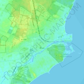
Name: Åhus topographic map, elevation, terrain.
Location: Åhus, Kristianstads kommun, Skåne County, Sweden (55.90157 14.25635 55.95242 14.33102)
Average elevation: 5 m
Minimum elevation: -2 m
Maximum elevation: 15 m
Thank you for supporting this site ❤️
Make a donation
Make a donation
Other topographic maps
Click on a map to view its topography, its elevation and its terrain.