Geolocate

Katoomba topographic map

Interactive map

Click on the map to display elevation.

About this map

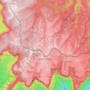
Name: Katoomba topographic map, elevation, terrain.

Location: Katoomba, Sydney, Blue Mountains City Council, New South Wales, 2780, Australia (-33.73607 150.26083 -33.67181 150.33009)

Average elevation: 912 m

Minimum elevation: 412 m

Maximum elevation: 1,067 m

Other topographic maps

Click on a map to view its topography, its elevation and its terrain.

Dover Heights

Australia > New South Wales > Sydney

Average elevation: 20 m

Sydney

Australia > New South Wales > Sydney

The Hills district generally refers to the suburbs in north-western Sydney including the local government areas of The Hills Shire, parts of the City of Parramatta Council and Hornsby Shire. Actual suburbs and localities that are considered to be in the Hills District can be somewhat amorphous and variable.…

Average elevation: 32 m

Sydney

Australia > New South Wales > Sydney

Average elevation: 23 m

Collaroy Plateau

Australia > New South Wales > Sydney

Average elevation: 30 m

Surry Hills

Australia > New South Wales > Sydney

Average elevation: 35 m

Ultimo

Australia > New South Wales > Sydney

Average elevation: 28 m

Glenbrook

Australia > New South Wales > Sydney

Average elevation: 168 m

Leura

Australia > New South Wales > Sydney

Average elevation: 878 m

Camperdown

Australia > New South Wales > Sydney

Average elevation: 26 m