Geolocate

Hindoli Tehsil topographic map

Interactive map

Click on the map to display elevation.

About this map

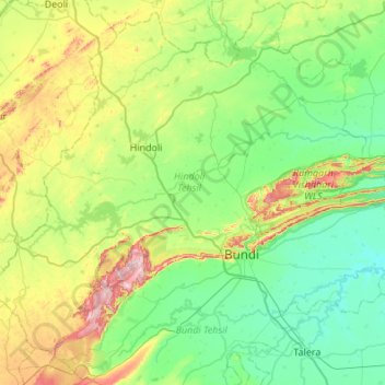
Name: Hindoli Tehsil topographic map, elevation, terrain.

Location: Hindoli Tehsil, Bundi, Rajasthan, 323023, India (25.28775 75.26177 25.75115 75.80498)

Average elevation: 306 m

Minimum elevation: 223 m

Maximum elevation: 544 m

Other topographic maps

Click on a map to view its topography, its elevation and its terrain.

Jaipur

India > Rajasthan > Jaipur Tehsil

Average elevation: 408 m

Loonar

India > Rajasthan > Loonar

Average elevation: 119 m

Jaisalmer

India > Rajasthan

Average elevation: 144 m

Nagaur

India > Rajasthan

Average elevation: 340 m

Hindaun

India > Rajasthan > Hindaun

Average elevation: 230 m

Ajmer Tehsil

India > Rajasthan

Average elevation: 469 m

Mukandgarh

India > Rajasthan > Mukandgarh

Average elevation: 359 m

Raisinghnagar

India > Rajasthan > Raisinghnagar

Average elevation: 165 m

Sikar

India > Rajasthan

Average elevation: 400 m

Jaisalmer

India > Rajasthan > Jaisalmer

Average elevation: 242 m

Guru Shikhar, Abu

India > Rajasthan

Average elevation: 1,366 m

Nāgaur

India > Rajasthan

Average elevation: 350 m