
Make a donation
Lawrence topographic map
Click on the map to display elevation.
Make a donation
About this map
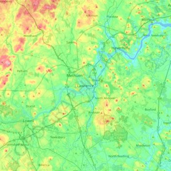
Name: Lawrence topographic map, elevation, terrain.
Location: Lawrence, Essex County, Massachusetts, United States (42.54704 -71.32311 42.86704 -71.00311)
Average elevation: 48 m
Minimum elevation: -5 m
Maximum elevation: 172 m
Make a donation
Other topographic maps
Click on a map to view its topography, its elevation and its terrain.
Amesbury
United States > Massachusetts > Essex County
Amesbury is located at 42°51′29″N 70°55′50″W / 42.85806°N 70.93056°W / 42.85806; -70.93056. According to the United States Census Bureau, the city has a total area of 13.7 square miles (35.5 km2), of which 12.3 square miles (31.8 km2) is land and 1.5 square miles (3.8 km2), or 10.65%, is…
Average elevation: 25 m
Make a donation
Deer Island
United States > Massachusetts > Essex County > Amesbury > Salisbury Point
Average elevation: 15 m
Make a donation
Plum Island
United States > Massachusetts > Essex County > Newbury
Maximum dune elevation is about 50 feet (15 m). In the deeper depressions and more sheltered regions between or next to the higher dunes are vernal pools in which black oak, red maple and black cherry can be found. In the underbrush are cranberry. The ferns, moss and leaf cover there shelter salamanders and…
Average elevation: 2 m
East Point/Henry Cabot Lodge,Jr., Memorial Park
United States > Massachusetts > Essex County > Nahant
Average elevation: 1 m
Make a donation
Make a donation
Hamilton
United States > Massachusetts > Essex County
According to the United States Census Bureau, the town has a total area of 14.9 square miles (38.6 km2), of which 14.2 square miles (36.7 km2) is land and 0.73 square miles (1.9 km2), or 4.89%, is water. Hamilton lies 5 miles (8 km) inland from Massachusetts Bay, and both the eastern and western portion of…
Average elevation: 19 m
Make a donation
Veasey Memorial Park
United States > Massachusetts > Essex County > Groveland > South Groveland
Average elevation: 34 m
Dix Park
United States > Massachusetts > Essex County > Beverly > Beverly Farms
Average elevation: 19 m