
Skeena-Queen Charlotte topographic map
Interactive map
Click on the map to display elevation.
About this map
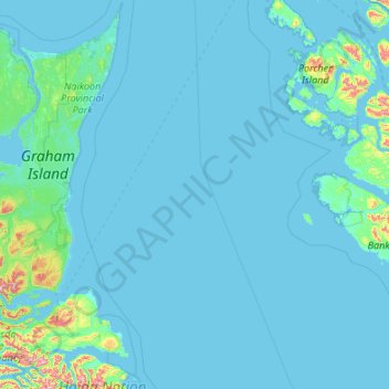
Name: Skeena-Queen Charlotte topographic map, elevation, terrain.
Location: Skeena-Queen Charlotte, Canada (52.92196 -131.87744 54.20196 -130.59744)
Average elevation: 37 m
Minimum elevation: -1 m
Maximum elevation: 1,032 m
Other topographic maps
Click on a map to view its topography, its elevation and its terrain.
Vancouver Island
The rain shadow effect of the island's mountains, as well as the mountains of Washington's Olympic Peninsula, creates wide variation in precipitation. The west coast is considerably wetter than the east coast. Average annual precipitation ranges from 6,650 mm (262 in) at Hucuktlis Lake on the west coast…
Average elevation: 411 m
Dog Lake
Canada > Ontario > Parry Sound District > Unorganized Centre Parry Sound
Average elevation: 245 m
Area C (Hagensborg/Talchako/Atnarko)
Canada > British Columbia > Central Coast Regional District
Average elevation: 1,432 m
Quebec
Canada > Quebec > Urban agglomeration of Québec
Quebec City was built on the north bank of the Saint Lawrence River, where it narrows and meets the mouth of the Saint-Charles River. Old Quebec is located on top and at the foot of Cap-Diamant, which is on the eastern edge of a plateau called the promontory of Quebec (Quebec hill). Because of this topographic…
Average elevation: 117 m
Area G (Upper Similkameen/Hedley)
Canada > British Columbia > Regional District of Okanagan-Similkameen
Average elevation: 1,305 m
Pickering
Canada > Ontario > Durham Region
The city covers an area of 231 square kilometres (89 sq mi) with an elevation of 89 metres (292 ft).
Average elevation: 170 m
Victoria
Canada > British Columbia > Capital Regional District
Victoria, British Columbia, is situated on the southern tip of Vancouver Island, Canada, and boasts a diverse and varied topography. The city is characterized by rolling hills, rugged coastal cliffs, and lush valleys, providing a striking contrast between mountainous terrain and flatland areas. To the north…
Average elevation: 17 m
Little Sagamu River
Canada > Ontario > Kenora District > Unorganized Kenora District
Average elevation: 7 m