
Make a donation
Florida topographic map
Click on the map to display elevation.
Make a donation
Florida
Florida's topography is characterized by its predominantly flat landscape, with the highest elevation being Britton Hill at just 345 feet (105 meters) above sea level, making it the lowest high point of any U.S. state. The state is primarily divided into three physiographic regions: the Atlantic Coastal Plain, the East Gulf Coastal Plain, and the Florida Uplands. The coastal plains feature sandy beaches, wetlands, and barrier islands along both the Atlantic Ocean and the Gulf of Mexico, supporting diverse ecosystems, including the famous Florida Keys. In contrast, the Florida Uplands, located in the central part of the state, are marked by rolling hills and extensive pine forests, creating a slight elevation compared to the coastal regions. Florida is also home to numerous lakes, such as Lake Okeechobee, and a vast network of wetlands, including the Everglades, which play a critical role in local ecosystems and water management.
Make a donation
About this map
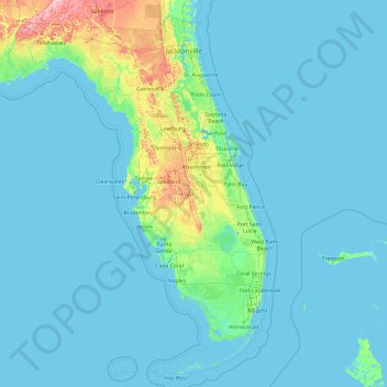
Name: Florida topographic map, elevation, terrain.
Location: Florida, United States (24.39631 -87.63490 31.00076 -79.97431)
Average elevation: 6 m
Minimum elevation: -3 m
Maximum elevation: 111 m
Make a donation
Other topographic maps
Click on a map to view its topography, its elevation and its terrain.
Mancos
United States > Colorado > Montezuma County
According to the United States Census Bureau, Mancos has a total area of 0.6 square miles (1.6 km2), all of it recorded as land. The town is located in the Mancos River valley at an elevation of approximately 7,000 feet (2,100 m). The Mancos River was named by Spanish explorers (Rio de los Mancos - "River of…
Average elevation: 2,166 m
Make a donation
Make a donation
Make a donation
Make a donation
Wesley Chapel
United States > Florida > Pasco County
According to the United States Census Bureau, the CDP has a total area of 6.1 square miles (16 km2), of which 6.1 square miles (16 km2) is land and 0.04 square miles (0.10 km2) (0.49%) is water. The elevation is about 100 feet (30 m), combined with an inland location, creates more temperature variation in the…
Average elevation: 19 m
Burkhardt
United States > Wisconsin > Saint Croix County > Town of Saint Joseph
Average elevation: 273 m
Make a donation
Make a donation
Forrest Hill
United States > Connecticut > Northeastern Connecticut Planning Region > Woodstock
Average elevation: 154 m
Make a donation
Make a donation
Make a donation
Make a donation
Make a donation
Allensworth
United States > California > Tulare County
Allensworth sits at an elevation of 213 feet (65 m), the same elevation as the huge and historically important Tulare Lake shore when it was full. The community is located in the ZIP Code 93219 and in the area code 661.
Average elevation: 63 m