
Make a donation
Susquehanna River topographic map
Click on the map to display elevation.
Make a donation
About this map
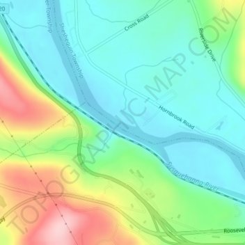
Name: Susquehanna River topographic map, elevation, terrain.
Location: Susquehanna River, 18850, United States, Susquehanna River (41.80482 -76.49421 41.80954 -76.48421)
Average elevation: 272 m
Minimum elevation: 212 m
Maximum elevation: 408 m
Make a donation
Other topographic maps
Click on a map to view its topography, its elevation and its terrain.
Connecticut
Connecticut's topography is a diverse landscape characterized by a mix of mountainous regions, lowlands, and coastal areas. The state can be broadly divided into five geographical regions: the Taconic Section, which features the highest point in Connecticut at Bear Mountain (2,380 feet / 725 meters), has steep…
Average elevation: 118 m
Jim Edgar Panther Creek State Fish and Wildlife Area
United States > Illinois > Cass County
Average elevation: 183 m
Make a donation
Delaware
Delaware is on a level plain, with the lowest mean elevation of any state in the nation. Its highest elevation, located at Ebright Azimuth, near Concord High School, is less than 450 feet (140 m) above sea level. The northernmost part of the state is part of the Piedmont Plateau with hills and rolling surfaces.
Average elevation: 16 m
Make a donation
Daphne
United States > Alabama > Baldwin County
The topography of Daphne is quite consistent from a gently sloping sea level on the west to low rolling hills further east. Generally, the entire city lies no more than 150 feet above sea level. The land along the Daphne bay coast, like other land throughout the county, is rich with sandy-loam type soils.
Average elevation: 25 m
Make a donation
Make a donation
Crater Lake
United States > Oregon > Klamath County
The lake is 5 by 6 miles (8.0 by 9.7 km) across, with a caldera rim ranging in elevation from 7,000 to 8,000 feet (2,100 to 2,400 m) and an average lake depth of 1,148 feet (350 m). The lake's maximum depth has been measured at 1,949 feet (594 m), which fluctuates slightly as the weather changes. On the basis…
Average elevation: 1,971 m
Lake Tahoe
United States > California > Placer County
Lake Tahoe has a dry-summer continental climate (Dsb in the Köppen climate classification), featuring warm, dry summers and chilly winters with regular snowfall. Mean annual precipitation ranges from over 55 inches (1,400 mm) for watersheds on the west side of the basin to about 26 inches (660 mm) near the…
Average elevation: 2,077 m
Make a donation
Blacksburg
United States > Virginia > Montgomery County
In the mid-1600s, English colonists were still uncertain of what lay beyond the Allegheny Mountains, whose topography and possession by native inhabitants, Tutelo-speaking tribes, were a barrier to expanded settlement by the Colony of Virginia. Abraham Wood, who commanded Fort Henry on the frontier (now the…
Average elevation: 621 m
Make a donation
Wilmington
United States > Vermont > Windham County
Wilmington experiences a humid continental climate (Koppen Dfb) with warm, humid summers and cold (sometimes severely cold) winters. While snowfall can vary greatly from year to year in nearby towns like Bennington and Brattleboro, Wilmington's snowfall is consistently heavy each year because of its elevation…
Average elevation: 578 m
Make a donation
Vermont
The topography and climate make sections of Vermont subject to large-scale flooding. Incidents include the Great Vermont Flood of 1927, which killed 84 and damaged much of the state's infrastructure, the flood of 1973, which covered many of the state's roads in the southeast, and Tropical Storm Irene in 2011,…
Average elevation: 348 m
Newton
United States > Massachusetts > Middlesex County
Geologically Newton is located within the topographic lowland of the Boston Basin of the Appalachian Mountain chain. This lowland is surrounded by a ring of highland drumlins which were left after the last glaciation twelve thousand years ago.
Average elevation: 38 m
Make a donation
Arizona
Arizona is well known for its desert Basin and Range region in the state's southern portions, which is rich in a landscape of xerophyte plants such as the cactus. This region's topography was shaped by prehistoric volcanism, followed by the cooling-off and related subsidence. Its climate has exceptionally hot…
Average elevation: 1,229 m
Make a donation
Make a donation
Barrington
United States > Rhode Island > Bristol County
Barrington lies on a low, mostly flat plain bordering the sea. This plain, composed mostly of layers of clay, gravel, sand, and silt soils, was formed by a melting glacier towards the end of the last ice age. Bedrock underlying the soil is largely composed of shales, sandstone, and conglomerate rock, with some…
Average elevation: 4 m
Florida
Florida's topography is characterized by its predominantly flat landscape, with the highest elevation being Britton Hill at just 345 feet (105 meters) above sea level, making it the lowest high point of any U.S. state. The state is primarily divided into three physiographic regions: the Atlantic Coastal Plain,…
Average elevation: 6 m
Make a donation
Burkhardt
United States > Wisconsin > Saint Croix County > Town of Saint Joseph
Average elevation: 273 m
Make a donation
Make a donation
Make a donation
Make a donation
Daviess County
The terrain of Daviess County is hilly, with its area completely devoted to agriculture or urban development. Its highest elevation (740 ft; 230 m ASL) is a rise one mile (1.6 km) NNE of Farlen. The county is drained by the White River flowing to the southwest, whose two main forks (East White and West White)…
Average elevation: 154 m
Make a donation
Make a donation
Make a donation
Make a donation
Make a donation
Tipton County
Due to topographic changes caused by the 1811–12 New Madrid earthquakes, part of what is now Tipton County was cut off from the state of Tennessee by a change in the course of the Mississippi River. The earthquake changed the course of the river near the settlement of Reverie, Tennessee. The old riverbed is…
Average elevation: 91 m
Madison
United States > Wisconsin > Dane County
The city is sometimes described as The City of Four Lakes, comprising the four successive lakes of the Yahara River: Lake Mendota ("Fourth Lake"), Lake Monona ("Third Lake"), Lake Waubesa ("Second Lake") and Lake Kegonsa ("First Lake"), although Waubesa and Kegonsa are not actually in Madison, but just south…
Average elevation: 284 m
Make a donation
Make a donation
Make a donation
Colorado
Colorado's topography is characterized by a diverse range of elevations and landforms, making it one of the most geologically varied states in the U.S. The state is dominated by the Rocky Mountains, which run north to south and include the highest peak in the contiguous United States, Mount Elbert, towering at…
Average elevation: 2,060 m
Make a donation
Tampa
United States > Florida > Hillsborough County
Tampa is characterized by a predominantly flat topography, with an average elevation around 16 to 49 feet (5 to 15 meters) above sea level. The terrain is marked by low-lying areas and gentle slopes, with the highest points in the vicinity reaching approximately 62 feet (19 meters). This landscape is…
Average elevation: 11 m
Pensacola
United States > Florida > Escambia County
The land is sloped up northward from Pensacola Bay, with most of the city at an elevation above that which a potential hurricane storm surge could affect.
Average elevation: 21 m
Make a donation