
Maar topographic map
Interactive map
Click on the map to display elevation.
About this map
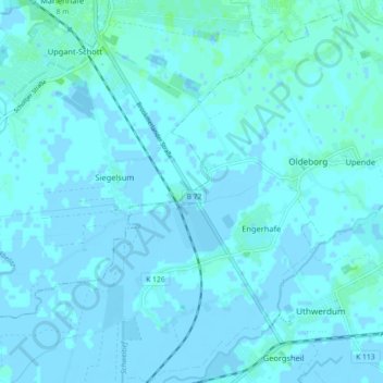
Name: Maar topographic map, elevation, terrain.
Location: Maar, Landkreis Aurich, Lower Saxony, 26529, Germany (53.49292 7.25722 53.50002 7.34691)
Average elevation: 1 m
Minimum elevation: -4 m
Maximum elevation: 5 m
Other topographic maps
Click on a map to view its topography, its elevation and its terrain.
Elbe
Germany > Lower Saxony > Landkreis Wolfenbüttel
Elbe, Samtgemeinde Baddeckenstedt, Landkreis Wolfenbüttel, Lower Saxony, 38274, Germany
Average elevation: 142 m
Aurich
Germany > Lower Saxony > Aurich
Aurich, Landkreis Aurich, Lower Saxony, Germany
Average elevation: 6 m
Goslar
Germany > Lower Saxony > Goslar
Goslar, Landkreis Goslar, Lower Saxony, Germany
Average elevation: 311 m
Cuxhaven
Germany > Lower Saxony > Cuxhaven
Cuxhaven, Landkreis Cuxhaven, Lower Saxony, Germany
Average elevation: 3 m