
Thank you for supporting this site ❤️
Make a donation
Make a donation
Wanne topographic map
Click on the map to display elevation.
Thank you for supporting this site ❤️
Make a donation
Make a donation
About this map
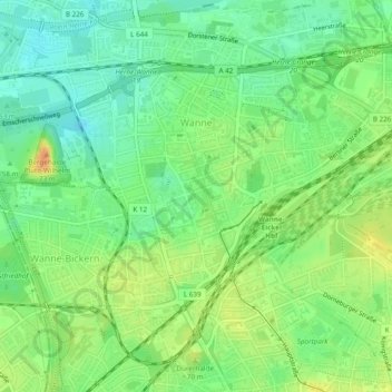
Name: Wanne topographic map, elevation, terrain.
Location: Wanne, Herne, Nordrhein-Westfalen, 44649, Deutschland (51.52236 7.12854 51.54229 7.17666)
Average elevation: 48 m
Minimum elevation: 31 m
Maximum elevation: 69 m
Thank you for supporting this site ❤️
Make a donation
Make a donation
Other topographic maps
Click on a map to view its topography, its elevation and its terrain.
Herne
Deutschland > Nordrhein-Westfalen > Herne
Für das Haushaltsjahr 2014 hat die Stadt Herne im Gesamtergebnisplan ein Haushaltsdefizit in ordentlichen Erträgen und Aufwendungen (einschließlich Finanzerträgen und -aufwendungen) in Höhe von 47,8 Millionen Euro (309 Euro je Einwohner) veranschlagt. Dies entspricht dem zweithöchsten…
Average elevation: 83 m