Geolocate

Latourell topographic map

Click on the map to display elevation.

About this map

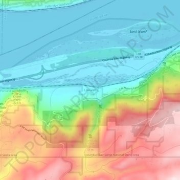
Name: Latourell topographic map, elevation, terrain.

Location: Latourell, Multnomah County, Oregon, United States (45.52068 -122.24120 45.56068 -122.20120)

Average elevation: 152 m

Minimum elevation: -3 m

Maximum elevation: 432 m

Other topographic maps

Click on a map to view its topography, its elevation and its terrain.

Forest Park

United States > Oregon > Multnomah County > Portland

Solidified lava from Grande Ronde members of the Columbia River Basalt Group underlie Forest Park. About 16 million years ago during the Middle Miocene, the Columbia River ran through a lowland south of its modern channel. Eruptions from linear vents in eastern Oregon and Washington flowed down this channel…

Average elevation: 91 m

Vernon

United States > Oregon > Multnomah County

Average elevation: 57 m

Northeast

United States > Oregon > Multnomah County > Gresham

Average elevation: 104 m

Arbor Lodge

United States > Oregon > Multnomah County > Portland

Average elevation: 43 m

Multnomah

United States > Oregon > Multnomah County > Portland

Average elevation: 143 m

Irvington

United States > Oregon > Multnomah County > Portland

Average elevation: 54 m

Fairview

United States > Oregon > Multnomah County

Average elevation: 26 m

North Central

United States > Oregon > Multnomah County > Gresham

Average elevation: 102 m

Powell Valley

United States > Oregon > Multnomah County > Gresham

Average elevation: 119 m

Overlook

United States > Oregon > Multnomah County > Portland

Average elevation: 33 m

Lents

United States > Oregon > Multnomah County > Portland

Average elevation: 86 m

Hollywood

United States > Oregon > Multnomah County > Portland

Average elevation: 61 m

Mirror Lake

United States > Oregon > Multnomah County

Average elevation: 89 m

Wilkes

United States > Oregon > Multnomah County > Portland

Average elevation: 43 m

Maywood Park

United States > Oregon > Multnomah County

Average elevation: 55 m

Ashcreek

United States > Oregon > Multnomah County > Portland

Average elevation: 129 m

Glenfair

United States > Oregon > Multnomah County > Portland

Average elevation: 86 m