
Thank you for supporting this site ❤️
Make a donation
Make a donation
Doerun topographic map
Click on the map to display elevation.
Thank you for supporting this site ❤️
Make a donation
Make a donation
About this map
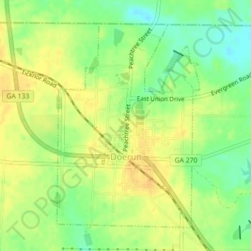
Name: Doerun topographic map, elevation, terrain.
Location: Doerun, Colquitt County, Georgia, 31744, United States (31.31202 -83.92580 31.33395 -83.90786)
Average elevation: 114 m
Minimum elevation: 98 m
Maximum elevation: 125 m
Thank you for supporting this site ❤️
Make a donation
Make a donation
Other topographic maps
Click on a map to view its topography, its elevation and its terrain.