
Santa Clara topographic map
Interactive map
Click on the map to display elevation.
About this map
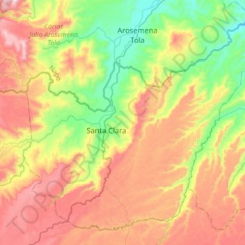
Name: Santa Clara topographic map, elevation, terrain.
Location: Santa Clara, Pastaza, Ecuador (-1.36474 -77.97081 -1.14751 -77.72357)
Average elevation: 810 m
Minimum elevation: 447 m
Maximum elevation: 1,263 m
Other topographic maps
Click on a map to view its topography, its elevation and its terrain.
Veracruz (Indillama) (Cab. en Indillama)
Veracruz (Indillama) (Cab. en Indillama), Pastaza, Ecuador
Average elevation: 855 m
Teniente Hugo Ortiz
Teniente Hugo Ortiz, Pastaza, Ecuador
Average elevation: 975 m
Montalvo (Andoas)
Montalvo (Andoas), Pastaza, Ecuador
Average elevation: 317 m