
Thank you for supporting this site ❤️
Make a donation
Make a donation
Colt Creek State Park topographic map
Click on the map to display elevation.
Thank you for supporting this site ❤️
Make a donation
Make a donation
Colt Creek State Park
The park's habitat consist primarily of mesic flatwoods co-dominated by cypress domes, hardwood hammocks and wetlands. Lands within the park are relatively flat, with an average elevation of 90 feet above sea level. Additionally, natural-looking lakes that formed from old lime rock mining operations are present. The park is home to many wildlife species.
Thank you for supporting this site ❤️
Make a donation
Make a donation
About this map
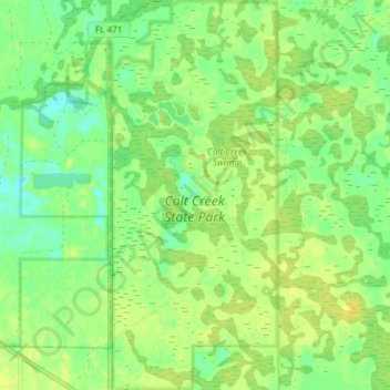
Name: Colt Creek State Park topographic map, elevation, terrain.
Location: Colt Creek State Park, Polk County, Florida, United States (28.25200 -82.05525 28.31761 -82.02355)
Average elevation: 28 m
Minimum elevation: 18 m
Maximum elevation: 35 m
Thank you for supporting this site ❤️
Make a donation
Make a donation
Other topographic maps
Click on a map to view its topography, its elevation and its terrain.
Thank you for supporting this site ❤️
Make a donation
Make a donation
Thank you for supporting this site ❤️
Make a donation
Make a donation
Thank you for supporting this site ❤️
Make a donation
Make a donation