
Thank you for supporting this site ❤️
Make a donation
Make a donation
Zetzwil topographic map
Click on the map to display elevation.
Thank you for supporting this site ❤️
Make a donation
Make a donation
About this map
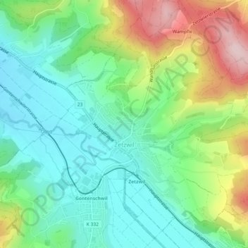
Name: Zetzwil topographic map, elevation, terrain.
Location: Zetzwil, Bezirk Kulm, Aargau, 5732, Schweiz (47.27563 8.13846 47.30198 8.18348)
Average elevation: 578 m
Minimum elevation: 486 m
Maximum elevation: 766 m
Thank you for supporting this site ❤️
Make a donation
Make a donation
Other topographic maps
Click on a map to view its topography, its elevation and its terrain.
Stierenberg
Schweiz > Aargau > Bezirk Kulm > Menziken
Der Stierenberg (Schreibweise lt. Bundesamt für Landestopografie: Stereberg) mit einer Höhe von 872 m ü. M. ist eine Erhebung westlich von Menziken im Schweizer Kanton Aargau.
Average elevation: 709 m
Thank you for supporting this site ❤️
Make a donation
Make a donation